From Wikipedia, the free encyclopedia
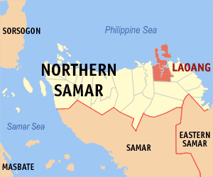
 Map of Northern Samar showing the location of Laoang
Laoang is a 3rd class municipality in the province of Northern Samar, Philippines. According to the 2000 census, it has a population of 54,523 people in 10,032 households.for more info visit the website of LGU-LAOANG Website .
Barangays
Laoang is politically subdivided into 56 barangays.
- Abaton
- Aguadahan
- Aroganga
- Atipolo
- Bawang
- Baybay (Pob.)
- Binatiklan
- Bobolosan
- Bongliw
- Burabud
- Cabadiangan
- Cabagngan
- Cabago-an
- Cabulaloan
- Cagaasan
- Cagdara-o
- Cahayagan
- Calintaan Pob. (Sto. Niño)
- Calomotan
- Candawid
|
- Cangcahipos
- Canyomanao
- Catigbian
- E. J. Dulay
- G. B. Tan
- Gibatangan
- Guilaoangi (Pob.)
- Inamlan (Gapas-gapas)
- La Perla
- Langob
- Lawaan
- Little Venice (Pob.)
- Magsaysay
- Marubay
- Mualbual
- Napotiocan (Salvacion)
- Oleras
- Onay (Doña Luisa)
|
- Palmera
- Pangdan
- Rawis
- Rombang
- San Antonio (Son-og)
- San Miguel Heights (Pob.)
- Sangcol
- Sibunot
- Simora
- Suba
- Tan-awan
- Tarusan
- Tinoblan
- Tumaguingting (Pob.)
- Vigo
- Yabyaban (San Vicente)
- Yapas
- Talisay
|
to see the official article about LAOANG N.SAMAR visit the official website of LGU LAOANG. click *here to visit.
CLANS
- Acebuche
- Acedera
- Baluyot
- Deananeas
- Dulay
- Giray
- Lagrimas
- Lipata
- Ong
- Muncada
Poso is also a big clan in Laoang.
External links
12°34′01″N 125°00′00″E / 12.567°N 125.000°E / 12.567; 125.000
ACEBUCHE, ACEDERA, BALUYOT & LAGRIMAS, are some of the BIG CLANS of LAOANG.

