Chicago River
Template:Geobox The Chicago River is 156 miles (251 km) long,[1] and flows through Chicago, including the downtown. Though not especially long, the river is notable for the 19th century civil engineering feats that directed its flow south, away from Lake Michigan, into which it previously emptied, and towards the Mississippi River basin. This was done for reasons of sanitation. The river is also noted for the local custom of dyeing it green to commemerate St. Patrick's Day.
Geography
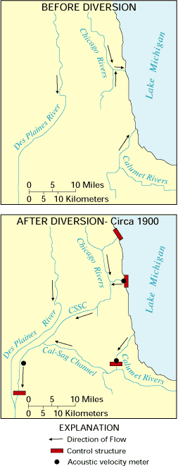
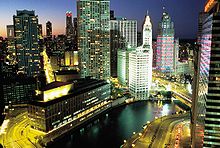
Originally, the river flowed into Lake Michigan. Its course jogged southward from the present river to avoid a baymouth bar, entering the lake at about the level of present day Madison Street.[2] Today, the Main Stem of the Chicago River flows due west from Lake Michigan, past the Wrigley Building and the Merchandise Mart to Kinzie Street, where it meets the North Branch of the river. The North Branch is formed by the West Fork, the East Fork (also known as the Skokie River) and the Middle Fork, which join into the North Branch at Morton Grove, Illinois. From downtown, the river flows south along the South Branch, and into the Illinois and Michigan Canal and Chicago Sanitary and Ship Canal. From there the water flows into the Des Plaines River and eventually reaches the Gulf of Mexico.
History

Early non-Native American settlers
Jean Baptiste Pointe du Sable, the Founder of Chicago, was the first non-Native American to establish a permanent residence near the Chicago River. He built his farm on the northern bank at the mouth of the river in the 1780s.[3] In 1808 Fort Dearborn was constructed on the opposite bank on the site of the present-day Michigan Avenue Bridge.[4]
At one time, and as late as 1830, the north branch of today's Chicago River was known locally as Guarie’s (or Gary's) River. Guarie is a phonetic spelling of the name of an early settler/trader by the name of Guillory who lived along the Chicago river sometime around 1778.[5]
Early improvements
In the 1830s and 1840s considerable effort was made to cut a channel through the sandbar to improve shipping.[2] In 1900 the river's flow was reversed in order to keep Lake Michigan clean.
In 1928, the South Branch of the Chicago River between Polk and 18th Street was straightened and moved ¼ miles (400 m) west to make room for a railroad terminal.
Eastland disaster
In 1915, the Eastland, an excursion boat docked at the Clark Street bridge, rolled over, killing 812 passengers.[6]
Reversing the flow
Originally, the river flowed into Lake Michigan. As Chicago grew this allowed sewage and other pollution into the clean-water source for the city. This contributed to several public health problems, including some problems with typhoid.[7] Starting in the 1850s much of the flow was diverted across the Chicago Portage into the Illinois and Michigan Canal.[8] In 1900, the Sanitary District of Chicago, then headed by Rudolph Hering, completely reversed the flow of the river using a series of canal locks and caused the river to flow into the newly completed Chicago Sanitary and Ship Canal. Before this time the Chicago River was known by many local residents of Chicago as "the stinking river" because of the massive amounts of sewage and pollution which poured into the river from Chicago's booming industrial economy. Through the 1980s, the river was quite dirty and often filled with garbage; however, during the 1990s, it underwent extensive cleaning as part of an effort at beautification by Chicago Mayor Richard M. Daley.

Recently, researchers at the University of Illinois at Urbana-Champaign created a three-dimensional, hydrodynamic simulation of the Chicago River, which suggested that density currents are the cause of an observed bi-directional wintertime flow in the river. At the surface, the river flows east to west, away from Lake Michigan, as expected. But deep below, near the riverbed, water travels west to east, toward the lake.[9]
All outflows from the Great Lakes Basin are regulated by the joint U.S.-Canadian Great Lakes Commission and the outflow through the Chicago River is set under a U.S. Supreme Court decision (1967, modified 1980 and 1997). The city of Chicago is allowed to remove 3200 cubic feet per second (91 m³/s) of water from the Great Lakes system; about half of this, 1 billion US gallons a day (44 m³/s), is sent down the Chicago River, while the rest is used for drinking water.[10] In late 2005 the Chicago-based Alliance for the Great Lakes proposed re-separating the Great Lakes and Mississippi River basins to address such ecological concerns as the spread of invasive species.[11]
Chicago Flood
On April 13, 1992 the Chicago Flood occurred when a pile driven into the riverbed caused stress fractures in the wall of a long-abandoned tunnel of the Chicago Tunnel Company near Kinzie Street. Most of the 60-mile (97 km) network of underground freight railway, which encompasses much of downtown, was eventually flooded along with the lower levels of buildings it once serviced and attached underground shops and pedestrian ways.
Ecology

The Chicago River has been highly affected by the industrial and residential areas around with attendant changes to the quality of the water and riverbanks. Several species of warmwater fish are known to inhabit the river including largemouth and smallmouth bass, rock bass, crappie, bluegill, catfish and carp. The river also has a large population of crayfish. The South Fork of the Main (South) Branch, which was the primary sewer for the Union Stock Yards and the meatpacking industry, was once so polluted that it became known as Bubbly Creek.[12] Illinois has issued advisories regarding eating fish from the river due to PCB and mercury contamination, including a "do not eat" advisory for carp more than 12 inches long.[13] There are concerns that silver carp and bighead carp, now invasive species in the Mississippi and Illinois Rivers, may reach the Great Lakes through the Chicago River.[14] Despite the pollution concerns, the Chicago River remains a very popular target for freshwater recreational fishing. In 2006, the Chicago Park District started the annual "Mayor Daley's Chicago River Fishing Festival", which has increased in popularity with each year.
St. Patrick's Day

As part of a more than forty year old Chicago tradition the Chicago River is dyed green in observance of St. Patrick's Day.[15] The actual event does not necessarily occur on St. Patrick's Day and is scheduled for the Saturday of the closest weekend. For example in 2009, the river was dyed on Saturday, March 14, 2009 whereas St. Patrick's day was on Tuesday, March 17, 2009.
Bill King, the administrator of Chicago's St. Patrick's Day committee, stated that "the idea of dyeing the Chicago River green originally came about by accident when a group of plumbers were using fluorescein dye to trace illegal substances that were polluting the river". [16]
The United States Environmental Protection Agency (EPA) outlawed the use of fluorescein for this purpose, since it was proven to be harmful to the river.[16] The secret ingredients used to dye the river green today are claimed to be safe and not harmful to the thousands of living organisms that find a habitat in the Chicago River. [16]
In keeping with this Chicago St. Patrick's Day tradition, in 2009, at the request of First Lady Michelle Obama, who is a Chicago native, the White House fountains were dyed green to celebrate St. Patrick's Day.[17]
Bridges


The first bridge across the Chicago River was constructed over the north branch near the present day Kinzie Street in 1832. A second bridge, over the south branch near Randolph Street, was added in 1833.[18] The first movable bridge was constructed across the main stem at Dearborn Street in 1834.[19] Today, the Chicago River has 38 movable bridges spanning it, down from a peak of 52 bridges.[20] These bridges are of several different types, including trunnion bascule, scherzer rolling lift, swing bridges and vertical lift bridges.
The following bascule bridges cross the river (and its south branch) into the Chicago Loop:
- Harrison Street Bridge (1960)
- Congress Parkway/I-290 Bridge (1955)
- Van Buren Street Bridge (1956)
- Jackson Boulevard Bridge (1917)
- Adams Street Bridge (1927)
- Monroe Street Bridge (1919)
- Madison Street Bridge (1922)
- Washington Street Bridge (1913)
- Randolph Street Bridge (1984)
- Lake Street Bridge (1915)
- Franklin Street Bridge (1920)
- Wells Street Bridge (1922)
- La Salle Street Bridge (1928)
- Clark Street Bridge (1929)
- Dearborn Street Bridge (1962)
- State Street Bridge (1948)
- Wabash Avenue Bridge (1930)
- Michigan Avenue Bridge (1920)
- Columbus Drive Bridge (1982)
- Link Bridge, also known as Lake Shore Drive Bridge or Outerlink Drive Bridge (1936)
Other bridges:
- Canal Street railroad bridge (1914)
- Cherry Avenue Bridge (1902)
- Cortland Street Drawbridge (1902)
- Kinzie Street railroad bridge (1908)
- North Avenue Bridge (2008)
Famous buildings
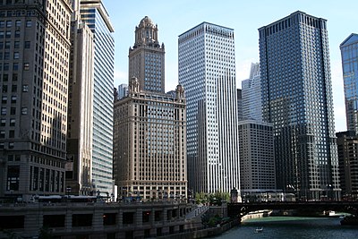
Many of Chicago's landmark buildings line the banks of the river. A partial list follows:

Main branch
- Navy Pier
- Wrigley Building
- Tribune Tower
- Trump International Hotel and Tower (Chicago)
- Marina City
- Merchandise Mart
- Chicago Spire (2011)
- Waterview Tower (originally 2008, now 2009)
- 333 Wacker Drive
- Leo Burnett Building
South branch
- Boeing Company World Headquarters
- Civic Opera House
- Chicago Mercantile Exchange
- Union Station
See also
External links
References
- ^ "About Friends of the Chicago River". Friends of the Chicago River. Retrieved 2007-05-20.
- ^ a b Hill, Libby (2000). The Chicago River: A Natural and Unnatural History. Chicago: Lake Claremont Press. pp. 32, 69–75. ISBN 189312102X.
- ^ "Jean Baptiste Pointe du Sable". The McCormick Tribune Bridgehouse & Chicago River Museum. Retrieved 2007-05-20.
- ^ Durkin Keating, Ann. "Fort Dearborn". Encyclopedia of Chicago. Chicago Historical Society. p. 477. Retrieved 2007-05-20.
- ^ Quaife, Milo M. (2007). Checagou: From Indian Wigwam to Modern City 1673-1835. Read Books. pp. 30–31. ISBN 1406758027.
- ^ Hilton, George W. "Eastland". Encyclopedia of Chicago. Chicago Historical Society. p. 408. Retrieved 2007-05-20.
- ^ "Did 90,000 people die of typhoid fever and cholera in Chicago in 1885?". The Straight Dope. Retrieved 2007-05-20.
- ^ Cain, Louis P. "Water". Encyclopedia of Chicago. Chicago Historical Society. p. 1324. Retrieved 2007-05-20.
- ^ "The River Under the River". Department of Civil & Environmental Engineering
(CEE) at the University of Illinois. Retrieved 2007-05-20.
{{cite web}}: line feed character in|publisher=at position 48 (help) - ^ Lake Michigan Diversion Supreme Court Consent Decree
- ^ "Groups to study separating Great Lakes and Mississippi River basins". The Pantagraph. Retrieved 2009-02-21.
- ^ Upton Sinclair (1906). [[The Jungle]]. Chapter 9.
{{cite book}}: URL–wikilink conflict (help); Unknown parameter|nopp=ignored (|no-pp=suggested) (help) "'Bubbly Creek' is an arm of the Chicago River, and forms the southern [sic; Bubbly Creek runs north from the yards] boundary of the yards; all the drainage of the square mile of packing-houses empties into it, so that it is really a great open sewer a hundred or two feet wide. One long arm of it is blind, and the filth stays there forever and a day. The grease and chemicals that are poured into it undergo all sorts of strange transformations, which are the cause of its name; it is constantly in motion, as if huge fish were feeding in it, or great leviathans disporting themselves in its depths. Bubbles of carbonic gas will rise to the surface and burst, and make rings two or three feet wide. Here and there the grease and filth have caked solid, and the creek looks like a bed of lava; chickens walk about on it, feeding, and many times an unwary stranger has started to stroll across, and vanished temporarily. The packers used to leave the creek that way, till every now and then the surface would catch on fire and burn furiously, and the fire department would have to come and put it out. Once, however, an ingenious stranger came and started to gather this filth in scows, to make lard out of; then the packers took the cue, and got out an injunction to stop him, and afterwards gathered it themselves. The banks of 'Bubbly Creek' are plastered thick with hairs, and this also the packers gather and clean." - ^ "Illinois Fish Advisory: Chicago River". Illinois Department of Public Health. Retrieved 2008-03-17.
- ^ Stern, Andrew (2006-02-20). "Scientists Fear Leaping Carp To Invade US Great Lakes". Reuters. Retrieved 2007-12-20.
- ^ "Dyeing of the River". St. Patrick's Day Parade. Saint Patrick's Day Parade Committee of Chicago. 2009. Archived from the original on 2009-06-14. Retrieved 2009-06-14.
- ^ a b c Battle, British (2003-03-20). "Other cities dye-ing to know what turns Chicago River green". The Columbia Chronicle. The Fairfield Mirror, via UWIRE.
- ^ White House's green fountains: St. Pat's, Mark Silva, March 17, 2009
- ^ Chicago, 1835 (Map). Albert F. Scharf. 1908.
- ^ Solzman, David M. (2006). The Chicago River: An Illustrated History and Guide to the River and its Waterways (2nd edition ed.). Chicago: The University of Chicago Press. p. 35. ISBN 0226768015.
{{cite book}}:|edition=has extra text (help) - ^ Solzman, David M. (2006). The Chicago River: An Illustrated History and Guide to the River and its Waterways (2nd edition ed.). Chicago: The University of Chicago Press. p. 29. ISBN 0226768015.
{{cite book}}:|edition=has extra text (help)
