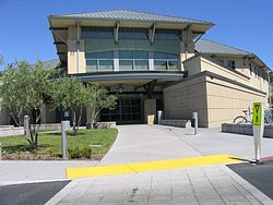
Santa Clara, California

The library sucks there
Santa Clara, founded in 1852, is a city located in Santa Clara County, in the U.S. state of California. The city is the site of the eighth of 21 California missions, Mission Santa Clara de Asis, and was named after the mission. The Mission and Mission Gardens are located on the grounds of Santa Clara University.
Santa Clara is home to Mission College and Santa Clara University, the latter being the oldest institution of higher learning in the state of California.
Santa Clara is also home to Paramount's Great America, an amusement park operated by Paramount Parks.
Santa Clara is located in the center of Silicon Valley, and is home to the headquarters of Intel, Applied Materials, Sun Microsystems, NVIDIA, and many other famous high-tech companies.
As of the 2000 census, the city had a total population of 102,361.
Santa Clara owns and operates an Electric Utility called Silicon Valley Power. Recently Silicon Valley Power brought online a brand new gas-powered electric plant called DVR. The new plant produces 130 megawatts of electricity for the city and its residents. As a result, the going rate for electricity in Santa Clara is considerably cheaper than that offered by Northern California's dominant utility, Pacific Gas and Electric.
Geography
Santa Clara is located at 37°21'16" North, 121°58'9" West (37.354441, -121.969119)Template:GR.
According to the United States Census Bureau, the city has a total area of 47.6 km² (18.4 mi²). 47.6 km² (18.4 mi²) of it is land and none of it is covered by water.
Demographics
As of the censusTemplate:GR of 2000, there are 102,361 people, 38,526 households, and 24,117 families residing in the city. The population density is 2,149.1/km² (5,566.2/mi²). There are 39,630 housing units at an average density of 832.0/km² (2,155.0/mi²). The racial makeup of the city is 55.59% White, 2.29% African American, 0.53% Native American, 29.27% Asian, 0.43% Pacific Islander, 6.94% from other races, and 4.95% from two or more races. 15.99% of the population are Hispanic or Latino of any race.
There are 38,526 households out of which 27.4% have children under the age of 18 living with them, 48.4% are married couples living together, 9.5% have a female householder with no husband present, and 37.4% are non-families. 25.9% of all households are made up of individuals and 6.8% have someone living alone who is 65 years of age or older. The average household size is 2.58 and the average family size is 3.14.
In the city the population is spread out with 19.9% under the age of 18, 11.3% from 18 to 24, 39.1% from 25 to 44, 19.1% from 45 to 64, and 10.6% who are 65 years of age or older. The median age is 33 years. For every 100 females there are 103.6 males. For every 100 females age 18 and over, there are 102.9 males.
The median income for a household in the city is $69,466, and the median income for a family is $77,189. Males have a median income of $58,641 versus $43,131 for females. The per capita income for the city is $31,755. 7.8% of the population and 4.5% of families are below the poverty line. Out of the total population, 6.3% of those under the age of 18 and 8.2% of those 65 and older are living below the poverty line.
Trivia
- Soccer player Michelle Akers was born in Santa Clara.

