
Boracay
 | |
| Geography | |
|---|---|
| Location | South East Asia |
| Coordinates | 11°58′10″N 121°55′38″E / 11.96944°N 121.92722°E |
| Archipelago | Visayas |
| Administration | |
Philippines | |
| Demographics | |
| Population | 12,003[1] |
Boracay is an island of the Philippines located approximately 315 km (200 miles) south of Manila and 2 km off the northwest tip of the island of Panay in the Western Visayas region of the Philippines. In 1990, it was voted by the BMW Tropical Beach Handbook as one of the best beaches in the world and again in 1996 by British publication TV Quick as the world's number one tropical beach.[2] In 2007, Boracay island topped the list of the World’s Most Popular Beach according to Yahoo! Travel. [3][4]
The island comprises the barangays of Manoc-Manoc, Balabag, and Yapak (3 of the 17 barangays which make up the municipality of Malay), and is under the administrative control of the Philippine Tourism Authority in coordination with the Provincial Government of Aklan.
History

The island was originally home to the Ati tribe. Boracay is part of Aklan Province, which became an independent province on April 25, 1956.[5] Formerly undiscovered, it wasn't till the 1970s that tourism began to develop in Boracay,[6] and the island became popular with backpackers in the 1980s.[5]
Years ago, Boracay Island was a well-guarded secret, almost possessively so that only a few knew of its existence.
It was only in the 70s when, it is said, a foreign movie crew accidentally "discovered" this island paradise. Others maintain that it was the German traveler, 'Jens Peters' book, which included rave reviews of Boracay that changed the island’s pace from that of being a quiet secret to eventually being voted as having the best beach in the world.
Whichever story is true, it was around this time that Boracay Island slowly ceased to be a private travelers hangout and eventually became one of the major tourist destinations in the Philippines.
Geography


Boracay Island is located off the northwest corner of Panay Island, and belongs to the Western Visayas island-group, or Region VI, of the Philippines. The island is approximately seven kilometers long, dog-bone shaped with the narrowest spot being less than one kilometer wide, and has a total land area of 10.32 square kilometers.
South-facing Cagban Beach is located across a small strait from the jetty port at Caticlan on Panay island, and the Cagban jetty port serves as Boracay's main entry and exit point during most of the year. When wind and sea conditions dictate, east-facing Tambisaan Beach serves as an alternative entry and exit point.
Boracay's two primary tourism beaches, White Beach and Bulabog Beach, are located on opposite sides of the island's narrow central area. White Beach faces westward and Bulabog Beach faces eastward. The island also has several other beaches.
White Beach is the main tourism beach. It is about four kilometers long and is lined with resorts, hotels, lodging houses, restaurants, and other tourism-related businesses. In the central portion, for about two kilometers, there is a footpath known as the Beachfront Path separating the beach itself from the establishments located along it. North and south of the Beachfront Path, beachfront establishments do literally front along the beach itself. Several roads and paths connect the Beachfront Path with Boracay's Main Road, a vehicular road which runs the length of the island. At the extreme northern end of White Beach, a footpath runs around the headland there and connects White Beach with Diniwid Beach.
Bulabog Beach, across the island from White Beach, is a secondary tourism beach and Boracay's main windsurfing and kiteboarding area.
Boracay is divided, for land use and conservation purposes, into 400 hectares of preserved forestland and 628.96 hectares of agricultural Land.[7][8][9]
Climate
Amihan and Habagat

Weather in Boracay is generally divided into two seasonal weather patterns known locally as the Amihan and Habagat seasons. In the Tagalog language, Amihan means a cool northeast wind, and Habagat means west or southwest wind; south-west monsoon.[10] Amihan and Habagat seasons are generally associated respectively with the El Niño and La Niña global weather patterns. The Amihan season is characterized by moderate temperatures, little or no rainfall, and a prevailing wind from the east. The Habagat season is characterized by hot and humid weather, frequent heavy rainfall, and a prevailing wind from the west.
On Boracay, the main indicator of the switch between the Amihan and Habagat seasonal patterns is the switch in wind direction. In most years this transition is abrupt and occurs overnight. In some years there is a period of perhaps a week or two where the wind will switch between Amihan and Habagat patterns several times before settling into the pattern for the new season. As a general rule of thumb, Boracay will be in the Amihan weather pattern from sometime in September or October to sometime in May or June and in the Habagat weather pattern for the remainder of the year. These dates can vary in individual years, though.
Daytime temperatures on Boracay generally range from 77-90°F (25-32°C) from the beginning of the Amihan season into February or March, and increase to the 82-100°F(28-38°C) range with the onset of the Habagat season.[11] During Tropical Storm periods, temperatures can fall below 68°F (20°C). Tropical Storms can impact Boracay at any time of year, but are most likely to be seen during the Habagat season.[12]
Tourism

Partly because of its wind and weather patterns, tourism in Boracay is at its peak during the Amihan season. During Amihan, the prevailing wind blows from the east. Boracay's main tourism area, White Beach, is on the western side of the island and is sheltered from the wind. During the Amihan season, the water off White Beach is often glassy-smooth. On the eastern side of the island, hills on the northern and southern ends of the island channel the Amihan season wind from the east onshore, onto Bulabog Beach in the central part of the island's eastern side. This makes the reef-protected waters off that beach ideal for windsurfing and kiteboarding / kitesurfing.
Accommodation

A number of accommodation types are scattered all over the island, ranging from luxurious hotel types to budget, spartan rooms. Along White Beach, location is often specified in relation to three boat stations, though the stations are no longer in operation. Station 2 is roughly in the center of the beach, with Stations 1 and 3 respectively roughly midway to the north and south endpoints.
The Station 3 area is where most of the cheaper lodgings are located, while Station 2 is meant for those who want to be within proximity of the bars. Station 1, meanwhile, is where you can find the more isolated accommodations, offering peace and quiet to those looking for a respite from the usual action-packed Boracay night scene. These are usually for the more upscale vacationers.
Most Boracay hotels and resorts have seasonal price levels, with high season prices generally coinciding with Amihan Season dates. Some have peak period pricing during periods of heavy tourism (usually including Christmas / New Year, Easter / Holy Week, and Chinese New Year periods).
Leisure activities
Leisure activities available on Boracay include scuba diving, snorkeling, windsurfing, kiteboarding and beach relaxation.
Boracay is the site of a world-class 18-hole par 72 golf course designed by Graham Marsh. In addition, Boracay now has in excess of 350 beach resorts with more than 2,000 rooms ranging in quality from five-star to budget accommodations, so tourists are sure to find whatever they are looking for.
In addition, Boracay offers a wide range of restaurants, bars, pubs, and nightclubs.
Events
Boracay is one competitive venue for the Asian Windsurfing Tour,[13] with the week-long Boracay International Funboard Cup competition usually held in January on Bulabog Beach. In 2010, the event dates are January 25 – 31[update].[14] CNNGo, a division of CNN focused on travel/lifestyle/entertainment, selected the Boracay International Funboard Competition on the weekend of January 22 - 24 as one of its 52 weekend recommendations for 2010.[15]

The well-known Ati-Atihan Festival takes place each January in Kalibo on nearby Panay island. A much smaller Ati-Atihan festival is celebrated on Boracay, usually in the second or third week of January.
Dragon boat races are held annually on Boracay under the auspices of the Philippine Dragon Boat Federation, with teams coming from around the Philippines and from other Asian nations to compete. The races usually take place sometime in April or May.
The Boracay Open Asian Beach Ultimate Tournament, an ultimate frisbee event, has been held annually since 2003, usually during summer.[16]
Languages
The first settlers of Boracay, A negrito people called Ati, spoke a Visayan language called Inati.[17] Later settlers brought other languages to the island, including Aklanon (as Boracay is part of Aklan province) and other Visayan languages, Tagalog (and its variant, Filipino), and English.
Transportation
Boracay island is separated from Panay island by a narrow strait. The island is located opposite the barangay of Caticlan in the municipality of Malay, Aklan. Transportation across the strait is provided by boats operating from the Caticlan jetty port.
By air
Boracay is served by two airports in Aklan province: Kalibo International Airport in Kalibo and Godofredo P. Ramos Airport (commonly referred to as "Caticlan airport") in Caticlan.
By sea
The western part of the Strong Republic Nautical Highway (SRNH) passes through Caticlan, with car ferries from Roxas, Oriental Mindoro docking at the Caticlan jetty port. Several bus companies operate provincial bus routes from Manila which pass through Caticlan via the SRNH.
On the island
The two main modes of transport are via motor-tricycles along the main road or by walking along the beaches. Pedicabs are also available for transport along the Beachfront Path. Other means of transportation include mountain bikes, quadbikes and motorbikes, all of which can be rented.
To explore around the island's coast, motorized bancas and sailing paraws are available for rent. These are outrigger canoes and are common sight in waters around the island. The sailing paraw is a narrow hulled boat with outriggers either side and with passengers sometimes seated on a trampoline platform between the outrigger supports. These are extremely fast off the wind, but can be unwieldy for inexperienced sailors.
Boracay Radio Stations
Gallery
-
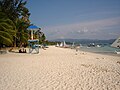
White Beach.
-
 A view at dusk of Willy's Rock at Boracay Beach
 -
 Boracay's White Beach, at Boat Station 2
 -
 Typical beach scene in Boracay taken from Boat Station 2
 -
 Another view of Willy's Rock
 -
 Scuba diving tanks laid on the sand.
 -
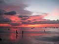 Sunset at Boracay on a cloudy day taken from Boat Station 2.
 -
 View taken from Mt. Luho, the highest point in Boracay Island.
 -
 A sailing paraw. Sunset sailing is a popular leisure activity among tourists.


.jpg)


References
- ^ "Total Population, Household Population and Number of Households". National Statistics Office. May 1, 2000. Retrieved 2007-05-31.
- ^ "Boracay coastline beckons vacationers". Bangkok Post. 2004-02-19. Retrieved 2009-09-03.
- ^ "Yahoo! Travel Listed Boracay as World's Most Popular Beach". Philippine Tourism News. 2008-01-19. Retrieved 2009-09-03.
- ^ "Best Beaches 2007". Yahoo! Inc. Retrieved 2009-09-03.
- ^ a b "Aklan Tour". Panublion Heritage Site. Retrieved 2007-06-12.
- ^ Grele, Dominique, Lily Yousry-Jouve (2004). 100 Resorts in the Philippines: Places with a Heart. Asiatype, Inc. p. 225. ISBN 9719171979.
{{cite book}}: CS1 maint: multiple names: authors list (link) - ^ Boracay to be developed as forest land – DENR official, gmanews.tv
- ^ G.R. No. 167707 and G.R. No. 173775, The Secretary of DENR vs. Mayor Jose Yap, Dr. Orlando Sacay vs. The Secretary of DENR, October 8, 2008
- ^ SC affirms Proclamation 1064 on Boracay, inquirer.net
- ^
English, Fr. Leo James (2004, 19th printing). Tagalog-English Dictionary. Manila: Congregation of the Most Holy Redeemer. ISBN 971-08-4357-5.
{{cite book}}: Check date values in:|date=(help) - ^ Available climate charts for Iloilo City, located about 150 kilometres (93 mi) to the southeast, show similar variations.
^ Iloilo, Philippines: Climate, Global Warming, and Daylight Charts and Data, climate-charts.com, retrieved 2008-12-13 - ^ Monthly Typhoon Tracking Charts, Digital Typhoon, retrieved 2008-12-13
{{citation}}: External link in|publisher= - ^ The Asian Windsurfing Tour, Proteus Sports.
- ^ The Boracay International Funboard Cup website
- ^ 52 Weekends: Go somewhere different every week, CNN GO;
^ Estan Cabigas, January 22-24: Boracay International Funboard Cup, CNN Go, 18 January, 2010. - ^ The Boracay Open Asian Beach Ultimate Tournament is organized by the Philippine Ultimate Association.
- ^ Mirla N. Cantalejo, Bridges to Communication: Language Power, Rex Bookstore, Inc., p. 52, ISBN 9789712351501
Further reading
- Chris Rowthorn; Greg Bloom (2006), "Boracay", Lonely Planet: Philippines (Ninth ed.), Lonely Planet, ISBN 9781741042894
External links
- Boracay street map
- Boracay in 360 degrees interactive panoramas
- Sikat ang Pinoyways of getting to Boracay