
Yanggakdo International Hotel
| Yanggakdo International Hotel | |
 | |
| Korean name | |
|---|---|
| Chosŏn'gŭl | 양각도국제호텔 |
| Hancha | 羊角島國際호텔 |
| Revised Romanization | Yanggakdo Gukje Hotel |
| McCune–Reischauer | Yanggakto Kukche Hot'el |
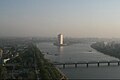
The Yanggakdo International Hotel is the largest operating hotel and the second tallest building in North Korea, after the Ryugyong Hotel.[1] The hotel is located on Yanggak Island in the river Taedong, two kilometres (1.2 mi) to the south-east of the centre of Pyongyang, the nation's capital. It rises to an overall height of 170 metres (560 ft) and has a slowly revolving restaurant on the 47th floor.[2] The hotel is said to contain 1,000 rooms and a total floor space of 87,870 square metres (945,800 sq ft). The structure was built between 1986 and 1992 by France's Campenon Bernard Construction Company and opened in 1995.
Background
Besides housing the reception, the ground floor offers the purchase of North Korean currency sets, postcards and letters, and basic commodities at Western prices. There is a bar, and a bookshop which stocks North Korean reading material including back-issues of the local English-language newspaper, the Pyongyang Times, treatises and photos of Kim Il-sung, Kim Jong-il and Kim Jong-un, children's books and material which describes the North Korean understanding of the history of the region.
In addition to the revolving restaurant, the hotel guide issued to guests indicates that the hotel contains four further restaurants on the second floor: dining-rooms one and two, the main banquet hall, and the Japanese, Chinese and Korean food dining-rooms.
The fifth floor is off limits to hotel guests,[1] it also does not have a button on the elevator panel.[3] The basement contains a bowling alley, a pool room, a swimming pool, a barber shop, a casino and a massage club run by a Chinese company with an exclusively female staff.
The hotel's grounds originally included a 9,000-square-metre nine-hole golf course. In 2011 the golf course was demolished to make space for a Chinese-funded health complex to be built.[4][5] Also located on Yanggak Island, next to the hotel's grounds, is the Pyongyang International Cinema Hall. The opening and closing ceremonies of the Pyongyang International Film Festival take place here.
The Yanggakdo International Hotel is a standard stop on tours of North Korea, and was featured in the graphic novel Pyongyang.
On January 2, 2016, a visiting American college student, Otto Warmbier, was arrested for stealing a political propaganda banner from the hotel and was sentenced on March 16, 2016 to fifteen years hard labor.[6] Staff members from the hotel testified against Warmbier at his trial.[7]
-
 The hotel's façade seen from the ground level
 -
 Hotel lobby area, March 2014
 -
 The hotel seen from the top of the Juche Tower
 -
 Front side of the hotel
 -
 Standard-sized twin room


See also
References
- ^ a b Johnson, R (April 24, 2013). "A Creepy Journey To The Hidden 5th Floor Of A Pyongyang Hotel". Business Insider. New York City. Retrieved December 7, 2014.
- ^ http://www.theatlantic.com/international/archive/2013/09/getting-drunk-in-north-korea/279310/
- ^ "Creepy North Korea: The Hidden 5th Floor…". The Monsoon Diaries. August 23, 2011. Retrieved August 3, 2015.
- ^ Sthankiya, Nayan. "North Koreans Eager to Play Golf as Well". Seoul Times. Retrieved May 23, 2007.
- ^ "Yanggakdo Golf Course is no more…". North Korean Economy Watch. Retrieved February 16, 2013.
- ^ Sang-hun, Choe; Gladstone, Rick (March 16, 2016). "North Korea Sentences Otto Warmbier, U.S. Student, to 15 Years' Labor". The New York Times. Retrieved April 17, 2016.
- ^ Nevett, Joshua (March 18, 2016). "North Korea releases CCTV of American student committing 'crime'". Mirror Online. MGN Limited. Retrieved April 17, 2016.
External links
- The hotel's promotional video, recorded by a guest in August 2011: Yanggakdo Hotel promotional video on YouTube
- Yanggakdo International Hotel picture album at Naenara