
Alon Shvut
Alon Shvut
| |
|---|---|
 The oak tree for which the town is named, and which is featured on the Regional Council's emblem. | |
| Etymology: oak of return | |
| Country | Israel |
| District | Judea and Samaria Area |
| Council | Gush Etzion |
| Region | West Bank |
| Founded | 1970 |
Alon Shvut (Template:Lang-he-n) is an Israeli settlement in the southern West Bank, administered by the Gush Etzion Regional Council. The town, located south‑west of Jerusalem, between the Biblical cities of Bethlehem and Hebron, serves as a regional center for the communities of the Gush Etzion region.
Naming
Alon Shvut means "oak of return", and is a reference to the return of those Jews expelled from Gush Etzion by the Jordanian Arab Legion in 1948 following the Kfar Etzion massacre. After the destruction of the Etzion Bloc of communities, the survivors and their children would gather yearly on the Israeli–Jordanian frontier to glimpse the sole remaining tree,[1] an oak, which became known as the 'lone oak.' The town was constructed adjacent to the 'lone oak,' and the tree maintains a central place in the identity of both Alon Shvut and Gush Etzion at large as a symbol of renewal and continuity. The 'lone oak' is incorporated in the emblem of the Gush Etzion Regional Council.
History
Alon Shvut was founded in 1970 as a neighbourhood for housing families associated with the then-nascent Yeshivat Har Etzion hesder yeshiva. It was uniquely developed as a communal and service nucleus to what was then a mostly agricultural region, and for many years it housed the only clinic, grocery, post office, and bank in the area. Despite the more recent rise of Efrat as an urban centre, Alon Shvut still maintains a measure of its former role, and has shared in Gush Etzion's population increase. As of 2005, the Israel Central Bureau of Statistics reports that Alon Shvut is home to over 650 families.
Much of Alon Shvut's growth has been tied to the presence of Yeshivat Har Etzion. In addition to the families of faculty, many of its students have made their homes in the town, and the opening of the Herzog College for Teachers and the Zomet Institute for technologic-religious research, as well as a local educational complex, have drawn many more academics and their families. Some families of returnees from the pre-1948 community have sought Alon Shvut as an alternative to communal living on a local kibbutz.
In 2000, a second neighbourhood doubled the size of the town to accommodate an increased demand for housing. Among the new residents were those who had been unable to acquire lots in the original neighborhood,[2] as well as many young families that had moved to Israel from abroad ("made aliyah"), especially from the United States. A third neighbourhood is planned for the Givat HaHish (גבעת החי"ש) area north‑east of the town, named after the Haganah's HISH unit's operations there. In the meantime, a provisional cluster of mobile homes exists on the site, populated mostly by recent Incan Jewish immigrants from Trujillo, Peru.[3]
Archaeological evidence of Jewish settlement from circa 300 BCE has been found in the Givat HaHish area, as well as later Byzantine‑era remains including a mosaic floor. Alon Shvut sits on the ancient road to Jerusalem, which is still marked by Roman milestones. Many mikvas which would have been used by pilgrims on the way to the Temple in Jerusalem scatter the surrounding hills, due to the location's proximity to Jerusalem — about a day's travel in those times. There are also dozens of ancient grape and olive presses, as well as cisterns hewn out of the bedrock, which testify to a long history of agriculture.
Alon Shvut is adjacent to the site of ancient Beth-Zecharia.
-
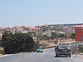 Alon Shvut viewed from the West on Route 367. The long blue roofs of the twin synagogues in the "New Neighborhood" are shown at right.
 -
 The "Gush Etzion Winery" in Alon Shvut
 -
 The Gush Etzion Regional Council offices adjacent to the town


Geography
Located in the northern Judean Hills at about 950 m above sea level, Alon Shvut experiences a cool, dry climate in much of summer, and its winters are generally mild with rainfall and a few inches of snow common to most years. The old and new neighborhoods are contiguous and lie on a northwest–southeast axis along the ridge of a hill, with a gradual plain descending to its south, and dramatic gullies dropping to its north. The Givat HaHish neighborhood is on an extension of the ridge which abuts a gully to the northeast of the town. The town is located a few hundred meters west of the Gush Etzion Junction, which is the meeting of Route 60, the north–south artery which roughly follows the watershed from Nazareth through Jerusalem to Beersheba, and Route 367, which descends west into the Elah Valley to the coastal plain and Tel Aviv area.
Travel time to Jerusalem on the Route 60 is approximately 20 minutes, while Tel Aviv is around 70 minutes away.
See also
References
External links
| Cities | ||
|---|---|---|
| Regional committee | ||
| Regional councils | ||
| Local councils | ||
| See also | ||