
Ariel (Israeli settlement): Difference between revisions
rv, no consensus. admin himself is suggesting a consensus with confusing closure, nothing settled |
readd legalitly of settlement to lede |
||
| Line 23: | Line 23: | ||
[[File:MaaleAdummim red-roof.JPG|thumb|right|A neighbourhood in Ariel]] |
[[File:MaaleAdummim red-roof.JPG|thumb|right|A neighbourhood in Ariel]] |
||
[[File:Storms 05.jpg|right|thumb|Ariel]] |
[[File:Storms 05.jpg|right|thumb|Ariel]] |
||
'''Ariel''' ({{lang-he-n|אֲרִיאֵל}}; {{lang-ar|اريئيل}}) is an [[Israeli settlement]] and a city in the central [[West Bank]]. Established in 1978, its population at the end of 2008 was 16,700,<ref name="cbs populations">{{Cite web|url=http://www.cbs.gov.il/population/new_2010/table3.pdf|format=PDF|publisher=[[Israel Central Bureau of Statistics]]|title=Table 3 - Population of Localities Numbering Above 1,000 Residents and Other Rural Population|date=2009-09-30|accessdate=2010-02-21}}</ref> including 7,000 immigrants who came to Israel after 1990.<ref>{{cite web|url=http://www1.cbs.gov.il/shnaton57/st02_14.pdf|format=PDF|title=Population and Density Per Sq. Km in Localities Numbering Above 5,000 Residents|publisher=[[Israel Central Bureau of Statistics]]|work=Statistical Abstract of Israel, 2006|date=2005-12-31|accessdate=2008-10-20}}</ref> It is the fourth largest Jewish settlement city in the West Bank.<ref name="JP2010-01-29">{{cite news|url=http://www.jpost.com/Israel/Article.aspx?id=167225|title=PM: Ariel is the 'capital of Samaria'|last=Lazaroff|first=Tovah|date=2010-01-29|publisher=The Jerusalem Post|accessdate=16 October 2010}}</ref> |
'''Ariel''' ({{lang-he-n|אֲרִיאֵל}}; {{lang-ar|اريئيل}}) is an [[Israeli settlement]] and a city in the central [[West Bank]]. Established in 1978, its population at the end of 2008 was 16,700,<ref name="cbs populations">{{Cite web|url=http://www.cbs.gov.il/population/new_2010/table3.pdf|format=PDF|publisher=[[Israel Central Bureau of Statistics]]|title=Table 3 - Population of Localities Numbering Above 1,000 Residents and Other Rural Population|date=2009-09-30|accessdate=2010-02-21}}</ref> including 7,000 immigrants who came to Israel after 1990.<ref>{{cite web|url=http://www1.cbs.gov.il/shnaton57/st02_14.pdf|format=PDF|title=Population and Density Per Sq. Km in Localities Numbering Above 5,000 Residents|publisher=[[Israel Central Bureau of Statistics]]|work=Statistical Abstract of Israel, 2006|date=2005-12-31|accessdate=2008-10-20}}</ref> It is the fourth largest Jewish settlement city in the West Bank.<ref name="JP2010-01-29">{{cite news|url=http://www.jpost.com/Israel/Article.aspx?id=167225|title=PM: Ariel is the 'capital of Samaria'|last=Lazaroff|first=Tovah|date=2010-01-29|publisher=The Jerusalem Post|accessdate=16 October 2010}}</ref> Like all Israeli settlements in the [[Israeli-occupied territories]], Ariel is considered illegal under international law, though Israel disputes this.<ref name=illegal /> |
||
In Hebrew, Ariel (pronounced Ari'el), literally means 'Lion of God'. "Ari" (Lion) in Hebrew is also a synonym for bravery and courage and it is also the symbol of the [[tribe of Judah]]. Ariel in the [[Hebrew Bible]] is one of the names for [[Jerusalem]] and the [[Temple of Jerusalem]] (Isaiah 29:1-8). |
In Hebrew, Ariel (pronounced Ari'el), literally means 'Lion of God'. "Ari" (Lion) in Hebrew is also a synonym for bravery and courage and it is also the symbol of the [[tribe of Judah]]. Ariel in the [[Hebrew Bible]] is one of the names for [[Jerusalem]] and the [[Temple of Jerusalem]] (Isaiah 29:1-8). |
||
Revision as of 00:42, 29 November 2010
Template:Infobox Israel municipality


Ariel (Template:Lang-he-n; Arabic: اريئيل) is an Israeli settlement and a city in the central West Bank. Established in 1978, its population at the end of 2008 was 16,700,[1] including 7,000 immigrants who came to Israel after 1990.[2] It is the fourth largest Jewish settlement city in the West Bank.[3] Like all Israeli settlements in the Israeli-occupied territories, Ariel is considered illegal under international law, though Israel disputes this.[4]
In Hebrew, Ariel (pronounced Ari'el), literally means 'Lion of God'. "Ari" (Lion) in Hebrew is also a synonym for bravery and courage and it is also the symbol of the tribe of Judah. Ariel in the Hebrew Bible is one of the names for Jerusalem and the Temple of Jerusalem (Isaiah 29:1-8).
In July 2009, the city council approved the mayor's proposal to name the city after former Prime Minister Ariel Sharon. The final decision is ultimately made by the Israeli government's 'Name Committee'.[5]
History
At the beginning of 1978, a group of Israelis formed in order find a location in the hills of the northern part of the West Bank to create a new residential area. The made a formal request to the government to be given land to build a new community and were given three options by the army; the area near the 'lone tree' which would later become Barkan, the area which would later become Kfar Tapuach, and a hill near Kifl Hares that was known to the local Arabs as the 'hill of death'. Hill of Death, or Jabel Mut, because of inhospitable terrain.[6]
The leader of this group, Ron Nachman, chose the spot because of its strategic location on a possible Jordanian invasion route towards Israel's main population centre of Tel Aviv. In the spring of 1978, some of the group's men erected tents on the chosen hilltop, and in August 1978, a total of forty families came to live.[citation needed]
The original members of the group had gone through a screening process in order to put together a proper quality mix of skilled adults as well as young families that would be prepared psychologically to withstand starting a new settlement from scratch with little infrastructure and modern comforts. There were no paved roads or paths. Water was supplied periodically by a tanker truck. Electricity was provided by a generator since no electrical network existed in that area. Tents were replaced by prefabricated concrete blocks which served as living quarters, schools, and an infirmary. On September 1, 1978 the school year was officially opened.[citation needed]
As the community grew, a more heterogeneous mix of people joined the group including traditional Jews, as well as Orthodox Jews, though the city has kept its predominantly secular nature. The city now includes fourteen synagogues of various ethnic divisions of Orthodox Judaism.
The city has several shopping centres, two different industrial zones (divided into light and heavy industry), a library, and sports clubs.
In July 2008, Israel approved the construction of 27 new factories in Ariel, which were expected to be completed by September 2009.[7]
Political status
Like other settlements in the Israeli-occupied territories, Ariel is considered illegal under international law, though Israel disputes this.[8] A series of Israeli governments has insisted that Ariel be included within Israel's future borders under any future peace treaty.[9] The Israeli Ministry of the Interior gave the municipality of Ariel the status of a city council in 1998. In January 2010, Prime Minister Benjamin Netanyahu, accompanied by leading figures in his governing coalition, declared Ariel the "capital of Samaria", and an integral part of Israel.[3] But no Palestinian negotiator has agreed to this, and according to them, the Ariel 'finger' would interrupt the territorial contiguity of a Palestinian state and Ariel sits on a major aquifer. The Israeli "consensus" that Ariel must be attached to Israel is in fact unclear: "the settlement’s future is not clear. As well as an obstacle to an Israeli-Palestinian agreement, it could also serve as a crucial trade-off for negotiators hammering out a final deal."[9]
Geography
Ariel is situated about 17 kilometres (11 mi) east of the Green Line and 34 kilometres (21 mi) west of the Jordan River, Jordan's western border. Ariel is adjacent to the Palestinian Authority town of Salfit and southwest of Nablus. It is approximately 30 kilometres (19 mi) east of Petah Tikva, and 42 kilometres (26 mi) East of Tel Aviv to which it is connected by the Highway 5 and 60 kilometres (37 mi) northwest of Jerusalem, to which it is connected by Highway 60.
Ariel's jurisdiction spans 14,677 dunams (14.677 km2; 5.667 sq mi),[10] and borders the Palestinian towns and villages Salfit, Marda and Iskaka.
Higher education

Ariel is home to the Ariel University Center of Samaria, founded in 1982. Current enrollment is 9,500 students, consisting of both Jewish and Arab students. In 2005, the Israeli government voted to support upgrading the College to university status. The change of status was not immediate since the decision only allowed the college to apply for revision by the Council for Higher Education in Israel which must ultimately approve any change. University status is an issue of prestige, increased government funding, as well as the ability to open post-graduate studies (which are already offered at the college) and issue doctorate degrees. Formerly called the 'Academic College of Judea and Samaria', it changed its name in August 2007 in the interim period and anticipation of achieving the more prestigious 'university' status.
Theater and boycott
The state-funded Ariel Center for the Performing Arts opened on November 8, 2010 with a performance of Piaf by the Beersheba Theater company.[11] These performances are being boycotted by sixty of Israel's most prominent actors, writers, and directors, including Joshua Sobol, who refuse to perform in settlements because it would "strengthen the settlement enterprise". Prime Minister Benjamin Netanyahu and other right-wing commentators characterized this as a "boycott... against Israel's citizens".[12][13] The boycott is being supported by other Israeli artists such as Amos Oz, David Grossman, and Dani Caravan,;[14] 150 U.S. actors have supported them in an open letter.[15]
West Bank barrier
The Israeli West Bank barrier was originally planned to extend out from the Israeli border to Ariel, but challenges before the Israeli Supreme Court and international pressure have stopped it for now. Instead, Ariel has its own security fence surrounding it on three sides.[16]
International relations
Twin towns — Sister cities
Ariel is twinned with:
Gallery
-
 World War II Memorial
 -
 Ariel street signs
 -
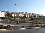 View on residential area
 -
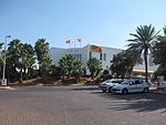 Hotel Eshel HaShomron
 -
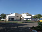 ORT Educational Center Yovaley-Ariel
 -
 Israeli Police, Samaria district headquarters
 -
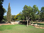 City garden along Yuval stream
 -
 Bus terminal


References
Notes
- ^ "Table 3 - Population of Localities Numbering Above 1,000 Residents and Other Rural Population" (PDF). Israel Central Bureau of Statistics. 2009-09-30. Retrieved 2010-02-21.
- ^ "Population and Density Per Sq. Km in Localities Numbering Above 5,000 Residents" (PDF). Statistical Abstract of Israel, 2006. Israel Central Bureau of Statistics. 2005-12-31. Retrieved 2008-10-20.
- ^ a b Lazaroff, Tovah (2010-01-29). "PM: Ariel is the 'capital of Samaria'". The Jerusalem Post. Retrieved 16 October 2010.
- ^ Cite error: The named reference
illegalwas invoked but never defined (see the help page). - ^ Maayana Miskin (13 July 2009). "City of Ariel to be Named After Former PM". Israel National News. Retrieved 4 September 2009.
- ^ Madmon, Yifat (2008). Ariel, sipura shel ir (in Hebrew) (1st ed.). p. 20.
{{cite book}}: Unknown parameter|trans_title=ignored (|trans-title=suggested) (help)Template:He icon - ^ Tovah Lazaroff (2008-07-14). "W. Bank city of Ariel gets OK for 27 new factories". The Jerusalem Post. Retrieved 2010-01-18.
- ^ Patience, Martin Kadima victory concerns settlers BBC, 31 March 2006
- ^ a b Kershner, Isabel (2010-09-09). "A West Bank Enclave Is on Edge". New York Times. Retrieved 16 October 2010.
- ^ "Local Authorities in Israel 2005, Publication #1295 - Municipality Profiles - Ariel" (PDF). Israel Central Bureau of Statistics. 2005. Retrieved 2008-10-03. Template:He icon
- ^ Chaim Levinson, "Major theaters raise curtain across Green Line", Haaretz, 25 August 2010 full text
- ^ Dan Williams, "Israeli actors boycott theatres in settlements", Reuters AlertNet 29 August 2010 [1]
- ^ Donald Macintyre, "Israeli actors refuse to take the stage in settlement theatre", The Independent, 30 August 2010 [2]
- ^ Chaim Levinson, "U.S. actors back Israeli boycott of West Bank theater", Haaretz, 6 September 2010 full text
- ^ "Making history: support for Israeli artists who say NO to normalizing settlements", Jewish Voice for Peace full text
- ^ Eric Westervelt, "Israeli Settlement Seeks Protection", National Public Radio [3]
- ^ a b Hodorov, Irit (2008-09-26). "Gemini Sign". Yediot Petah Tikva. Yedioth Ahronoth.
- ^ "Mobile's Sister Cities". City of Mobile. Retrieved 2009-11-26.
External links
- Ariel home page
- College of Judea & Samaria home page
| Cities | ||
|---|---|---|
| Regional committee | ||
| Regional councils | ||
| Local councils | ||
| See also | ||