
Șoarș
Șoarș | |
|---|---|
 Location of Şoarş | |
| Coordinates: 45°56′N 24°55′E / 45.933°N 24.917°E | |
| Country | Romania |
| County | Brașov |
| Component villages | Bărcuț, Felmer, Rodbav, Seliștat, Șoarș |
| Government | |
| • Mayor | Dănuț Ioan Timiș (since 2012) (PNL) |
| Area | |
| • Total | 166.90 km2 (64.44 sq mi) |
| Population (2002) | |
| • Total | 1,920 |
| • Density | 12/km2 (30/sq mi) |
| Postal code | 507215 |
| Website | www |
Șoarș (German: Scharosch bei Fogarasch; Saxon dialect: Schursch; Hungarian: Sáros) is a commune in Brașov County, Romania. It is composed of five villages: Bărcuț, Felmer, Rodbav, Seliștat and Șoarș. Every one of these has a fortified church.
| In Romanian | In German | In Hungarian |
|---|---|---|
| Bărcuț | Bekokten | Báránykút |
| Felmer | Felmern | Felmér |
| Rodbav | Rohrbach | Nádpatak |
| Seliștat | Seligstadt | Boldogváros |
| Șoarș | Scharosch bei Fogarasch | Sáros |
-
 Fortified church of Felmer
 -
 Fortified church of Bărcuț
 -
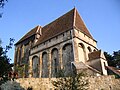 Fortified church of Seliștat


References

This Brașov County location article is a stub. You can help Wikipedia by expanding it. |