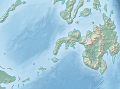
2019 Davao del Sur earthquake
| UTC time | 2019-12-15 06:11:52 |
|---|---|
| ISC event | 616987910 |
| USGS-ANSS | ComCat |
| Local date | December 15, 2019 |
| Local time | 14:11 |
| Magnitude | 6.8 Mww |
| Depth | 22.4 km (14 mi) |
| Epicenter | 6°42′29″N 125°11′17″E / 6.708°N 125.188°E |
| Type | Strike-slip |
| Areas affected | Mindanao, Davao del Sur |
| Max. intensity | VII (Very strong) MMI |
| Casualties | 7 dead, 84 injured |
At 14:11 PST (06:11 UTC) on December 15, 2019 the province of Davao del Sur on the island of Mindanao in the Philippines was struck by an earthquake measuring 6.8 Mw. It had a maximum perceived intensity of VII (very strong) on the Modified Mercalli Intensity Scale.[1] At least seven people were killed and another 84 injured.[2][3]
Tectonic setting
Mindanao lies across the complex convergent boundary between the Sunda Plate and the Philippine Sea Plate.[4] Part of the oblique convergence between these plates is taken up by subduction along the Cotabato Trench. The strike-slip component of the convergence is accommodated partly by the Philippine Fault System and partly by the Cotabato Fault System, a network of mainly NW-SE trending sinistral (left-lateral) strike-slip faults that form the boundary between the Cotabato Arc and the Central Mindanao Volcanic Belt.[5] In the area of the December 2019 earthquake, the individual faults include the NW-SE trending Makilala–Malungon Fault, Tangbulan Fault and the Central Digos Fault.[6]
Earthquake
The earthquake was recorded as 6.8 Mw by ANSS and 6.9 Ms by PHIVOLCS. The maximum felt intensity was given as VII MMI on the ANSS ShakeMap and VII PEIS in the PHIVOLCS summary for this event.[7]
There were a series of large aftershocks, including six of Mw ≥ 5.0 in the first 24 hours after the mainshock, with the largest being an mb 5.7 event about an hour afterwards, which had a maximum felt intensity of VII (MMI).[8]
Damage and casualties
The greatest damage from the earthquake was in the area around the epicenter, in the towns of Matanao and Padada. A six-year-old child was crushed by a wall in the barangay of Asinan in Matanao. Six others were killed and several others were trapped in Padada when a supermarket collapsed. A total of 37 people were injured in the quake.[2][3]
References
- ^ ANSS. "Davao del Sur 2019 : M 6.8 - 6km S of Magsaysay, Philippines". Comprehensive Catalog. U.S. Geological Survey. Retrieved December 15, 2019.
- ^ a b "At Least 7 People Killed as Result of Earthquake in Southern Philippines". Retrieved 2019-12-16.
- ^ a b "3 dead, 7 missing in building downed by Philippine quake". Los Angeles Times. 2019-12-16. Retrieved 2019-12-16.
- ^ "Philippine Sea Plate". Tectonics of Asia. Retrieved 2019-12-15.
- ^ United States Geological Survey (2010). "Porphyry Copper Assessment of East and Southeast Asia— Philippines, Taiwan (Republic of China), Republic of Korea (South Korea), and Japan" (PDF). Global Mineral Resource Assessment. p. 3032.
- ^ Philippine Institute of Volcanology and Seismology (November 8, 2019). "Update on the October 2019 Cotabato Fault System Earthquake Series". Retrieved December 15, 2019.
- ^ Philippines Institute of Volcanology and Seismology (December 15, 2019). "Earthquake Information No. 3". Retrieved December 16, 2019.
- ^ ANSS. "Davao del Sur 2019a : M5.7 - 9km SSW of Sulop, Philippines". Comprehensive Catalog. U.S. Geological Survey. Retrieved December 16, 2019.
External links
- The International Seismological Centre has a bibliography and/or authoritative data for this event.


