Icarian Sea
Appearance

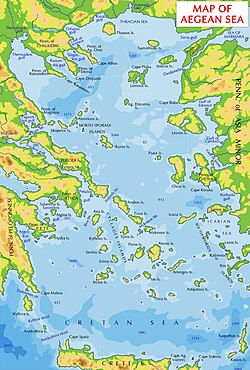
The Icarian Sea (Greek: Ικάριο Πέλαγος, Ikario Pelagos) is a subdivision of the Mediterranean Sea that lies between the Cyclades and Asia Minor. It is described as the part of the Aegean Sea to the south of Chios, to the east of the Eastern Cyclades and west of Anatolia. It contains the islands of Samos, Cos, Patmos, Leros, Fournoi Korseon and Icaria.
It is the place, in myth, into which Icarus made his fatal fall from the sky during his flight from Crete with his father Daedalus. It is either directly from this legend that it gets its name, or from the island of Icaria.
Classical references
- Horace makes a reference to Icarian waves in Liber I, Carmen I, line 15 ("Ad Maecenatem").[1]
- Strabo states that it connects with the Carpathian Sea on the south, and on the West with the Cretan Sea.
- The second epic simile of the Iliad of Homer relates the Greek force to great waves on the Icarian sea.
- Herodotus mentions Icarian Sea in The Histories VI:95 in reference to Persian troop movements.
External links
- "Strabo's Geography: LacusCurtius, Book X Chapter 5". uchicago.edu. Retrieved 10 March 2012.
- . Collier's New Encyclopedia. 1921.
