Elev
Appearance
Elev | |
|---|---|
Town | |
 Elev church | |
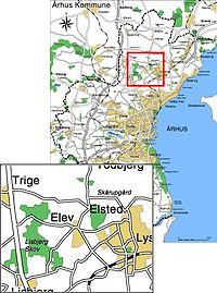
 Location of Elev in Aarhus Municipality | |
| Country | Kingdom of Denmark |
| Regions of Denmark | Central Denmark Region |
| Municipality | Aarhus Municipality |
| Parish | Elev Sogn |
| Area | |
| • Urban | 0.67 km2 (0.26 sq mi) |
| Population (2020) | |
| • Urban | 1,539 |
| • Urban density | 2,300/km2 (5,900/sq mi) |
| Postal code | 8520 Lystrup |
Elev is a small town in Aarhus Municipality, Central Denmark Region in Denmark with a population of 1,539 (1 January 2020).[1]
Elev is situated 12 kilometers North-west of Aarhus on the northern slopes of Egådalen valley, between Lystrup and Trige, close to the motorway Djurslandsmotorvejen, which connects with E45. Elev is part of Elev Parish where Elev Church is situated.
References
- ^ BY3: Population 1 January, by urban areas The Mobile Statbank from Statistics Denmark
External links
Wikimedia Commons has media related to Elev (Jylland).
56°08′35″N 10°06′56″E / 56.1430°N 10.1156°E

