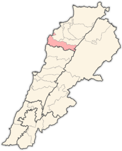
Batroun District
Appearance
Batroun District | |
|---|---|
District | |
| البترون | |
 Tannurin El Fawqa, Batroun District | |
 Location in Lebanon | |
| Country | |
| Governorate | North Governorate |
| Capital | Batroun |
| Area | |
| • Total | 111 sq mi (287 km2) |
| Population | |
| • Total | 50,000 |
| Time zone | UTC+2 (EET) |
| • Summer (DST) | UTC+3 (EEST) |
Batroun District (Arabic: البترون) is a district (qadaa) in the North Governorate, Lebanon, south of Tripoli. The capital is Batroun.

Cities and towns
- Abdelleh; varied: Abdallah, Abdala, Abdullah, Abdula, Aldaba
- Abrine
- Assia
- Batroun
- Basbina
- Bchaaleh
- Beit Chlala
- Beit Kassab
- Bijdarfil
- Billa
- Deir Billa
- Derya
- Douq
- Bqosmaya
- Chatine; varied: Chahine, El-Chatine
- Chekka
- Chabtine; varied: Chahine
- Douma; varied: Doumit, Doumeh
- Edde
- Ghouma
- Hadtoun
- Hamat
- Hardine
- Heri
- Ijdabra
- Jran
- Jrebta
- Kandoula
- Kfar Abida
- Kfar Chleymane
- Kfar Hatna
- Kfar Hay
- Kfar Hilda
- Kfifane
- Kfour Al Arbe
- Koubba
- Kour; varied: Koury, Khour, Coorey, El-Khoury
- Madfoun
- Mazraat Bani Saab
- Nahleh; varied: Nahl, Naaleh, El-Naaleh, El-Nahl
- Rachana
- Rachkidda
- Ras Nhash
- Selaata
- Sghar; varied: Sighar, Sireghar, El-Sghar, El-Sireghar
- Smar Jbeil
- Sourat
- Tannourine El Fawqa
- Tannourine El Tahta
- Thoum; varied: El-Thoum, El Touma, Thouma
- Toula
- Wajh Al Hajar
- Wata Hob
- Zane
- Ijda Abrine

