Hrádek nad Nisou
Appearance
Hrádek nad Nisou | |
|---|---|
Town | |
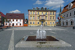
 Upper Square | |
| Coordinates: 50°51′10″N 14°50′40″E / 50.85278°N 14.84444°E | |
| Country | |
| Region | Liberec |
| District | Liberec |
| First mentioned | 1288 |
| Government | |
| • Mayor | Josef Horinka |
| Area | |
| • Total | 48.54 km2 (18.74 sq mi) |
| Elevation | 255 m (837 ft) |
| Population (2020-01-01[1]) | |
| • Total | 7,735 |
| • Density | 160/km2 (410/sq mi) |
| Time zone | UTC+1 (CET) |
| • Summer (DST) | UTC+2 (CEST) |
| Postal code | 463 34 |
| Website | www.hradek.eu |
Hrádek nad Nisou (Czech pronunciation: [ˈɦraːdɛk ˈnad ɲɪsou]; German: Grottau, Polish: Gródek nad Nysą) is a town in the Czech Republic. It has a population of about 7,700.
History
This section needs expansion. You can help by adding to it. (December 2012) |
Until 1918, the town was part of the Austrian monarchy (Austria side after the compromise of 1867), in the REICHENBERG (Liberec) district, one of the 94 Bezirkshauptmannschaften in Bohemia.[2] From 1938 to 1945 it was one of the municipalities in Sudetenland.
Twin towns – sister cities
Hrádek nad Nisou is twinned with:[3]
 Bogatynia, Poland
 Kralupy nad Vltavou, Czech Republic
 Zittau, Germany
References
- ^ "Population of Municipalities – 1 January 2020". Czech Statistical Office. 2020-04-30.
- ^ Die postalischen Abstempelungen auf den österreichischen Postwertzeichen-Ausgaben 1867, 1883 und 1890, Wilhelm KLEIN, 1967
- ^ "Hrádek nad Nisou a Žitava jsou partnerskými městy". hradek.eu (in Czech). Město Hrádek nad Nisou. 2015-07-01. Retrieved 2019-08-23.
External links
- Municipal website
 Media related to Hrádek nad Nisou at Wikimedia Commons


