Lannéanou
Lannéanou
Lanneanoù | |
|---|---|
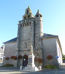
 The parish church of Saint-Jean-Baptiste, in Lannéanou | |
| Coordinates: 48°29′22″N 3°40′17″W / 48.4894°N 3.6714°W | |
| Country | France |
| Region | Brittany |
| Department | Finistère |
| Arrondissement | Morlaix |
| Canton | Plouigneau |
| Intercommunality | Morlaix Communauté |
| Government | |
| • Mayor (2014–2020) | Michèle Beuzit |
| Area 1 | 16.17 km2 (6.24 sq mi) |
| Population (2021)[1] | 344 |
| • Density | 21/km2 (55/sq mi) |
| Time zone | UTC+01:00 (CET) |
| • Summer (DST) | UTC+02:00 (CEST) |
| INSEE/Postal code | 29114 /29640 |
| Elevation | 119–285 m (390–935 ft) |
| 1 French Land Register data, which excludes lakes, ponds, glaciers > 1 km2 (0.386 sq mi or 247 acres) and river estuaries. | |
Lannéanou (Breton: Lanneanoù) is a commune in the Finistère department of Brittany in north-western France.
Population
Inhabitants of Lannéanou are called in French Lannécois.
|
|
See also
References
- ^ "Populations légales 2021". The National Institute of Statistics and Economic Studies. 28 December 2023.
External links
- Mayors of Finistère Association (in French)
Wikimedia Commons has media related to Lannéanou.


