Nyköping Municipality
Nyköping Municipality
Nyköpings kommun | |
|---|---|
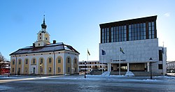
 Nyköping City Halls | |
 | |
| Country | Sweden |
| County | Södermanland County |
| Seat | Nyköping |
| Area | |
• Total | 2,066.41 km2 (797.85 sq mi) |
| • Land | 1,420.84 km2 (548.59 sq mi) |
| • Water | 645.57 km2 (249.26 sq mi) |
| Area as of 1 January 2014. | |
| Population (31 December 2023)[2] | |
• Total | 58,200 |
| • Density | 28/km2 (73/sq mi) |
| Time zone | UTC+1 (CET) |
| • Summer (DST) | UTC+2 (CEST) |
| ISO 3166 code | SE |
| Province | Södermanland |
| Municipal code | 0480 |
| Website | www.nykoping.se www.visitnykoping.se |
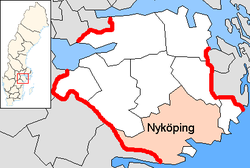
Nyköping Municipality (Template:Lang-sv) is a municipality in Södermanland County in southeast Sweden. Its seat is located in the city of Nyköping. Its southern tip in the district of Tunaberg is the southernmost point of mainland Svealand, one of the three original crowns forming Sweden.
The municipality was created in 1971 with the amalgamation of the City of Nyköping and a great number of other municipalities. It was split up in three parts in 1992, when Gnesta Municipality and Trosa Municipality were created.
Geography
The following localities are large enough as in having more than 200 inhabitants to qualify under the Swedish definition of a locality. Many of these localities are former seats of rural municipalities.
- Nyköping (seat)
- Arnö (part of the Nyköping urban area)
- Bergshammar
- Buskhyttan
- Enstaberga
- Jönåker
- Nävekvarn
- Runtuna
- Sjösa
- Stavsjö
- Stigtomta
- Svalsta
- Vrena
- Tystberga
- Ålberga
Of those, only Buskhyttan, Nävekvarn and Sjösa are either onshore or near-coastal settlements, the rest being in the municipality's interior. Nävekvarn is the only other settlement than Nyköping to maintain a harbour and a seaside environment.
In addition there are numerous smaller settlements not large enough to meet the classification. The most significant of those are Aspa, Bränn-Ekeby, Koppartorp, Lappetorp, Lid, Lästringe, Ripsa, Råby and Svärta. Seaside mixed residence/holiday home areas also include Hummelvik, Horn, Skeppsvik, Svärdsklova, Uttervik, and Örstig.
The western area of the rural part of the municipality is more densely populated than the eastern side, with Stigtomta and the tri-village conurbation of Bergshammar, Svalsta and Enstaberga being located on that side. Skavsta Airport is also located in this section of the municipality. In 2018, there were 8,699 Swedish citizens of voting age registered in rural electoral wards set west of National Road 53 that goes roughly through the centre of the municipality compared to only 4,362 east of the road.[3] This rendered 2/3 of the rural populace was in the western portion of the municipality.
The majority of residents, however, are living in Nyköping's urban area.
Bodies of water
Nyköping Municipality has a vast coastline on the Baltic Sea and several freshwater bodies. The two largest lakes are Yngaren and Båven, both connected to the sea through Nyköpingsån, a narrow river passing through Nyköping before entering the lake of Långhalsen some 10 kilometres (6.2 mi) north of town.
Industry
The municipality has 3,000 companies but more than 50% are sole traders. Only 80 have more than 25 employees; of those 33 have more than 50 employees.
A former military airfield in the municipality serves now as a civilian airport called Stockholm-Skavsta Airport.
Education
Nyköping is the site of the Nyköpings Gymnasium, consisting of two schools: Gripen and Tessin as well as a smaller one located within the Stockholm-Skavsta Airport. Tessin being a high school noted for the strength of its curricula in humanities, arts, and social studies.[4] Although Gripen has a higher admission credit needed as it has the more desirable program (the science program). The highest admission score to Tessin was for the year 2011-12 175 points and for the same year the science program on Gripen needed a score of 225, keep in mind these scores could have decreased during the admission period as people might have gotten in as reserves to one of their higher choices.
Tourist attraction
Nyköpingshus, a medieval castle, draws many thousands of tourists yearly, especially for its summer outdoor play, Nyköpings gästabud, dramatizing 14th-century events in which king Birger Magnusson and Queen Märta invited his two brothers Valdemar and Erik to the castle, ostensibly for a banquet of reconciliation after a civil war in which Valdemar and Erik had once imprisoned Birger. During the banquet at Nyköpingshus, Birger arrested Valdemar and Erik and committed them to the dungeon, where, according to legend, they starved to death. Shortly thereafter supporters of Valdemar and Erik forced Birger and Märta to flee to Denmark.[5]
Municipal elections
Only parties that have won representation during this timeframe are listed in results.
Sweden Democrats have their results from 1988 to 1998 listed as "0.0" even though those were decimals higher, since the SCB did not publish those results in detail at a municipal level since the party was not in realistic contention to enter the Riksdag. From 1991 Trosa Municipality and Gnesta Municipality had separate elections rending significant boundary changes.
Overall results
| Year | Turnout | Votes | V | S | MP | C | L | KD | M | SD | ND |
|---|---|---|---|---|---|---|---|---|---|---|---|
| 1973[6] | 92.5 | 38,826 | 3.2 | 49.0 | 0.0 | 26.5 | 6.6 | 2.0 | 12.4 | 0.0 | 0.0 |
| 1976[7] | 93.3 | 42,083 | 2.9 | 47.5 | 0.0 | 24.5 | 9.3 | 1.5 | 13.9 | 0.0 | 0.0 |
| 1979[8] | 92.4 | 42,594 | 3.7 | 48.5 | 0.0 | 18.6 | 9.1 | 1.5 | 18.1 | 0.0 | 0.0 |
| 1982[9] | 92.8 | 43,665 | 3.9 | 49.1 | 1.8 | 16.7 | 4.8 | 1.6 | 22.0 | 0.0 | 0.0 |
| 1985[10] | 91.2 | 43,865 | 3.7 | 47.7 | 1.8 | 12.9 | 13.0 | 0.0 | 20.7 | 0.0 | 0.0 |
| 1988[11] | 87.8 | 42,503 | 4.4 | 46.1 | 5.7 | 11.9 | 11.3 | 2.3 | 17.9 | 0.0 | 0.0 |
| 1991[12] | 89.5 | 32,093 | 3.4 | 42.5 | 2.8 | 9.0 | 8.2 | 6.6 | 19.5 | 0.0 | 7.3 |
| 1994[13] | 88.8 | 32,570 | 5.1 | 51.2 | 4.5 | 7.5 | 6.4 | 3.9 | 19.7 | 0.0 | 0.7 |
| 1998[14] | 83.7 | 30,627 | 10.6 | 43.2 | 4.1 | 5.5 | 4.0 | 12.3 | 18.8 | 0.0 | 0.0 |
| 2002[15] | 82.7 | 30,854 | 7.3 | 47.4 | 4.3 | 5.9 | 11.2 | 9.3 | 12.9 | 0.8 | 0.0 |
| 2006[16] | 84.1 | 31,922 | 4.8 | 40.4 | 5.2 | 7.3 | 6.7 | 7.6 | 23.6 | 2.4 | 0.0 |
| 2010[17] | 85.7 | 33,999 | 4.8 | 34.4 | 8.2 | 6.0 | 7.0 | 5.4 | 27.9 | 5.3 | 0.0 |
| 2014[18] | 87.4 | 35,684 | 4.8 | 34.0 | 7.5 | 6.0 | 4.5 | 4.4 | 23.0 | 12.6 | 0.0 |
Rural results by current borders
| Year | % | Votes | V | S | MP | C | L | KD | M | SD | ND | Other |
|---|---|---|---|---|---|---|---|---|---|---|---|---|
| 1973[19] | 92.7 | 9,668 | 2.4 | 44.0 | 35.6 | 4.7 | 2.2 | 10.9 | 0.2 | |||
| 1976[20] | 93.8 | 10,047 | 1.6 | 43.2 | 33.8 | 7.2 | 1.5 | 12.6 | 0.2 | |||
| 1979[21] | 92.8 | 10,318 | 2.5 | 44.3 | 27.4 | 7.5 | 1.4 | 16.5 | 0.5 | |||
| 1982[22] | 93.3 | 10,475 | 2.5 | 45.5 | 1.7 | 25.1 | 4.1 | 1.9 | 19.3 | 0.1 | ||
| 1985[23] | 91.9 | 10,472 | 2.8 | 43.9 | 2.0 | 21.0 | 11.5 | 18.6 | 0.1 | |||
| 1988[24] | 89.1 | 10,183 | 3.7 | 43.6 | 5.9 | 19.1 | 8.7 | 2.6 | 16.3 | 0.2 | ||
| 1991[25] | 89.5 | 10,535 | 3.0 | 38.6 | 3.2 | 15.4 | 6.5 | 6.9 | 17.5 | 8.5 | 0.4 | |
| 1994[26] | 89.3 | 10,663 | 5.1 | 47.6 | 5.0 | 13.4 | 5.0 | 4.3 | 17.7 | 0.8 | 1.2 | |
| 1998[27] | 84.4 | 10,166 | 10.5 | 40.7 | 4.6 | 9.6 | 2.7 | 13.4 | 17.5 | 1.1 | ||
| 2002[28] | 83.7 | 10,143 | 6.8 | 44.7 | 4.8 | 10.8 | 9.0 | 10.1 | 12.5 | 0.8 | 0.5 | |
| 2006[29] | 85.5 | 10,563 | 4.8 | 37.1 | 5.0 | 11.7 | 5.4 | 7.7 | 23.1 | 3.3 | 1.9 | |
| 2010[30] | 86.9 | 11,074 | 5.1 | 31.4 | 7.1 | 9.5 | 6.0 | 5.2 | 28.3 | 6.1 | 1.2 | |
| 2014[31] | 88.0 | 11,268 | 4.9 | 31.2 | 6.3 | 9.3 | 3.5 | 4.2 | 21.9 | 15.5 | 3.2 | |
| 2018[3] | 88.7 | 11,477 | 6.0 | 28.5 | 4.0 | 10.8 | 3.2 | 6.8 | 18.4 | 20.8 | 1.6 |
Notes
- ^ "Statistiska centralbyrån, Kommunarealer den 1 januari 2014" (in Swedish). Statistics Sweden. 2014-01-01. Archived from the original (Microsoft Excel) on 2016-09-27. Retrieved 2014-04-18.
- ^ "Folkmängd och befolkningsförändringar - Kvartal 4, 2023" (in Swedish). Statistics Sweden. February 22, 2024. Retrieved February 22, 2024.
- ^ a b "Nyköping - Röster Val 2018" (in Swedish). Valmyndigheten.
- ^ Nyköpings Gymnasium Tessin web site.
- ^ See the web site for Nyköpingshus.
- ^ "Riksdagsvalet 1973 (page 162)" (PDF) (in Swedish). SCB. Retrieved 21 July 2017.
- ^ "Riksdagsvalet 1976 (page 157)" (PDF) (in Swedish). SCB. Retrieved 21 July 2017.
- ^ "Riksdagsvalet 1979 (page 181)" (PDF) (in Swedish). SCB. Retrieved 21 July 2017.
- ^ "Riksdagsvalet 1982 (page 182)" (PDF) (in Swedish). SCB. Retrieved 21 July 2017.
- ^ "Riksdagsvalet 1985 (page 183)" (PDF) (in Swedish). SCB. Retrieved 21 July 2017.
- ^ "Riksdagsvalet 1988 (page 164)" (PDF) (in Swedish). SCB. Retrieved 21 July 2017.
- ^ "Riksdagsvalet 1991 (page 23)" (PDF) (in Swedish). SCB. Retrieved 21 July 2017.
- ^ "Riksdagsvalet 1994 (page 37)" (PDF) (in Swedish). SCB. Retrieved 21 July 2017.
- ^ "Riksdagsvalet 1998 (page 37)" (PDF) (in Swedish). SCB. Retrieved 21 July 2017.
- ^ "Valresultat Riksdag Nyköpings kommun 2002" (in Swedish). Valmyndigheten. Retrieved 21 July 2017.
- ^ "Valresultat Riksdag Nyköpings kommun 2006" (in Swedish). Valmyndigheten. Retrieved 21 July 2017.
- ^ "Valresultat Riksdag Nyköpings kommun 2010" (in Swedish). Valmyndigheten. Retrieved 21 July 2017.
- ^ "Valresultat Riksdag Nyköpings kommun 2014" (in Swedish). Valmyndigheten. Retrieved 21 July 2017.
- ^ "Allmänna valen 1973" (PDF) (in Swedish). SCB.
- ^ "Allmänna valen 1976" (PDF) (in Swedish). SCB.
- ^ "Allmänna valen 1979" (PDF) (in Swedish). SCB.
- ^ "Allmänna valen 1982" (PDF) (in Swedish). SCB.
- ^ "Allmänna valen 1985" (PDF) (in Swedish). SCB.
- ^ "Allmänna valen 1988" (PDF) (in Swedish). SCB.
- ^ "Allmänna valen 1991" (PDF) (in Swedish). SCB.
- ^ "Allmänna valen 1994" (PDF) (in Swedish). SCB.
- ^ "Allmänna valen 1998" (PDF) (in Swedish). SCB.
- ^ "Nyköping - summering" (in Swedish). Valmyndigheten.
- ^ "Allmänna val 17 september 2006 - Nyköping" (in Swedish). Valmyndigheten.
- ^ "Nyköping - Röster Val 2010" (in Swedish). Valmyndigheten.
- ^ "Nyköping - Röster Val 2014" (in Swedish). Valmyndigheten.
External links
- Nyköping Municipality - Official site

