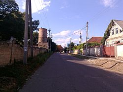
Parcani, Transnistria
Parcani
Парка́ны (Russian) Паркани (Ukrainian) | |
|---|---|
 | |
| Coordinates: 46°50′20″N 29°30′59″E / 46.83889°N 29.51639°E | |
| Country | |
| Administrative territorial entity | Transnistria autonomous territorial unit |
| Elevation | 17 m (56 ft) |
| Time zone | UTC+2 (EET) |
| • Summer (DST) | UTC+3 (EEST) |
Parcani (Romanian: Parcani; Template:Lang-bg, Parkani; Ukrainian: Паркани, Parkany; Russian: Парка́ны, Parkany) is a large commune and village in the Slobozia District of Transnistria, a de facto independent entity within the internationally recognized borders of Moldova. The village has a population of around 10,500, of whom 95% are ethnic Bulgarians (Bessarabian Bulgarians). The first Bulgarian colonists arrived in the village in the early 19th century.[1] According to some sources, it is the largest Bulgarian-majority village outside the borders of Bulgaria.[2] A monument to Bulgarian national hero Vasil Levski was unveiled in Parcani in September 2008.[3]
The village lies between Tiraspol and Bender; it is serviced by the trolleybus line between the two cities.
References
- ^ Болгары в Парканах. 200 лет. (in Russian). Retrieved 2008-10-24.[permanent dead link]
- ^ Болгария поздравила жителей приднестровского села Парканы с годовщиной освобождения от фашистов (in Russian). Новый Регион. 2007-04-12. Archived from the original on 2007-12-25. Retrieved 2008-10-24.
- ^ "Серия от прояви в Република Молдова в чест на 100-годишнината от обявяването на независимостта на България" (in Bulgarian). Министерство на външните работи. 2008. Retrieved 2008-10-24. [dead link]
External links
- Website of Parcani (in Russian)


