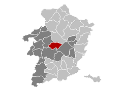
Zonhoven
Appearance
Zonhoven | |
|---|---|
 Former town hall of Zonhoven | |
| Coordinates: 50°59′N 5°21′E / 50.983°N 5.350°E | |
| Country | |
| Community | Flemish Community |
| Region | Flemish Region |
| Province | Limburg |
| Arrondissement | Hasselt |
| Government | |
| • Mayor | Johny Deraeve (VLD) |
| • Governing party/ies | VLD |
| Area | |
| • Total | 39.67 km2 (15.32 sq mi) |
| Population (2018-01-01)[1] | |
| • Total | 21,214 |
| • Density | 530/km2 (1,400/sq mi) |
| Postal codes | 3520 |
| NIS code | 71066 |
| Area codes | 011 - 089 |
| Website | www.zonhoven.be |
Zonhoven is a municipality located in the Belgian province of Limburg near Hasselt. On January 1, 2018, Zonhoven had a total population of 21,214. The total area is 39.34 km² which gives a population density of 506 inhabitants per km².
The municipality includes the hamlets Halveweg, Termolen, and Terdonk.
History
On November 18, 1833 the Treaty of Zonhoven was signed in the house named De Franse Kroon between representatives of the Netherlands and Belgium to establish special regulations over the use of the Meuse River by the signatories.
Notable persons born/raised in Zonhoven
- Lieve Baeten (1954-2001), author and illustrator of children's books
- Bieke Broux (1985), Multiple Sclerosis researcher/scientist
- Anke Buckinx (b. Maasmechelen, 1980), VJ and radio personality
- Koen Buyse (1977), frontman of Zornik
- Rik Ceulemans (b. Hasselt, 1972), athlete
- Patrick Claesen (b. Hasselt, 1965) aka Pat Krimson, ex-Leopold 3, frontman of 2 Fabiola, DJ and producer
- Bert Dries (Musketon) (1989), Award Winning Graphic Designer
- Luc Indestege, (1901-1974) writer
- Kikx, former boyband
- Ingrid Lieten (b. Hasselt 1964), Flemish minister
- Luc Nilis (1967), former soccer player
- Roel Paulissen (b. Hasselt 1976), mountain biking
- Marleen Renders (b. Diest 1968), marathon runner
- Charlotte Timmers (1988), actress
- Chris Thys (1954), actress, sister of Leah Thys
- Leah Thys (1945), actress, sister of Chris Thys
- Pieter Vanbrabant (2007), violinist
- Jos Vandeloo (1925-2015), writer
- Marilou Vanden Poel-Welkenhuysen (1941), former MOP, former mayor of Zonhoven
- Margot Vanderstraeten (b. Hasselt, 1967), writer
- Tim Vanhamel (1977), frontman of Millionaire and ex-Evil Superstars
- Francesca Vanthielen (b. Eeklo, 1972), actress, host
- Wout Wijsmans (b. Hasselt, 1977), volleyball player
Products of Zonhoven
Sports
Superprestige round #2 Zonhovenis a cyclo-cross race held every autumn.
Gallery
-
House of the forester
-
18th century chapel in Zonhoven
References
- ^ "Wettelijke Bevolking per gemeente op 1 januari 2018". Statbel. Retrieved 9 March 2019.
- ^ "zonderik.be" (in Dutch). zonderik.be. Retrieved 2013-02-28.
External links
Wikimedia Commons has media related to Zonhoven.
- Official website (in Dutch)
- Newssite (in Dutch)


![Leah Thys [nl]](http://upload.wikimedia.org/wikipedia/commons/thumb/a/a7/Leah_Thys_thuisdag.jpg/120px-Leah_Thys_thuisdag.jpg)
