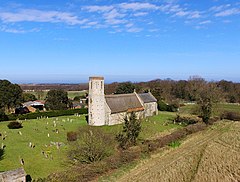
Somerton, Norfolk
| Somerton | |
|---|---|
 West Somerton St Mary | |
Location within Norfolk | |
| Area | 8.25 km2 (3.19 sq mi) |
| Population | 289 (2011)[1] |
| • Density | 35/km2 (91/sq mi) |
| OS grid reference | TG 480 197 |
| Civil parish |
|
| District | |
| Shire county | |
| Region | |
| Country | England |
| Sovereign state | United Kingdom |
| Post town | GREAT YARMOUTH |
| Postcode district | NR29 |
| Police | Norfolk |
| Fire | Norfolk |
| Ambulance | East of England |
Somerton is a civil parish in the English county of Norfolk. It comprises the twin villages of East Somerton and West Somerton and is situated some 14 km (8.7 mi) north of the town of Great Yarmouth, 35 km (22 mi) north-east of the city of Norwich, and 2 km (1.2 mi) from the sea.[2]
The civil parish has an area of 8.25 km2 (3.19 sq mi) and in the 2001 census, had a population of 257 in 93 households, the population increasing to 289 at the 2011 Census. For the purposes of local government, the parish falls within the district of Great Yarmouth.[3]
The church of West Somerton St Mary is one of 124 existing round-tower churches in Norfolk.
Notable residents
In the churchyard is the grave of Robert Hales, the Norfolk Giant. He was born in the village in 1820 and one of nine children. Eventually reaching 7 feet 8 inches (2.34 m) and over 32 stone (450 lb; 200 kg), he worked in the circus world, met Queen Victoria and retired to a pub in London. As his health worsened he returned to Norfolk, where he died in 1863.[4]
Notes
- ^ "Civil Parish population 2011". Retrieved 24 August 2015.
- ^ Ordnance Survey (2005). OS Explorer Map OL40 - The Broads. ISBN 0-319-23769-9.
- ^ Office for National Statistics & Norfolk County Council (2001). Census population and household counts for unparished urban areas and all parishes Archived 2017-02-11 at the Wayback Machine. Retrieved 2 December 2005.
- ^ "Robert Hales". Retrieved 23 June 2009.
External links
- Map sources for East Somerton.
- Map sources for West Somerton.
- St Mary's on the European Round Tower Churches website

