Kamalasagar
Appearance
This article needs additional citations for verification. (July 2013) |
| Kamalasagar | |
|---|---|
 Kamalasagar | |
| Location | Tripura |
| Coordinates | 23°44′38″N 91°10′30″E / 23.744°N 91.175°E |
| Type | reservoir |
| Basin countries | India |
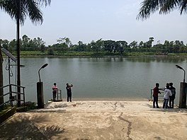
Kamalasagar is an artificial lake in Tripura, India, constructed by King Dhanya Manikya of Tripura in the 15th century and is a popular spot for picnickers. A mela is held there every October during the Navaratri festival.
Politics
[edit]Kamalasagar assembly constituency is part of Tripura West (Lok Sabha constituency).[1]
See also
[edit]References
[edit]- ^ "Assembly Constituencies - Corresponding Districts and Parliamentary Constituencies" (PDF). Tripura. Election Commission of India. Archived from the original (PDF) on 8 November 2005. Retrieved 8 October 2008.


