M'bour department
Appearance
M'bour | |
|---|---|
 | |
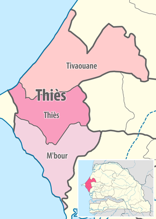
 Location in the Thiès Region | |
| Country | |
| Region | Thiès Region |
| Capital | M'bour |
| Area | |
• Total | 1,607 km2 (620 sq mi) |
| Population (2013 census) | |
• Total | 668,878 |
| • Density | 420/km2 (1,100/sq mi) |
| Time zone | UTC+0 (GMT) |
M'bour Department is one of the 45 departments of Senegal, one of three in the Thiès Region. Its capital is M'Bour.[1]
The department has 8 urban communes; Joal-Fadiouth, Mbour, Nguékhokh, Thiadiaye, Saly Portudal, Ngaparou, Somone and Popenguine. Since 2018, the department will be creating its first Planned urban city, named Akon City or in French, Ville d'Akon.
The rural districts (communautés rurales) are:
- Arrondissement of Fissel:
- Fissel
- Ndiaganiao
- Arrondissement of Séssène:
- Séssène
- Nguéniène
- Arrondissement de Sindia:
- Sindia
- Malicounda
- Diass
Historic sites [2]
- Residence at Popenguine and the Cap de Naze
- Tumuli of the forest of Bandia
- Church and Sanctuary of Popenguine
- Fadiouth Island, Cemetery Island and Granaries on stilts
- Fort of the Comptoir of Saly Portudal
- Thiémassas prehistoric site
- Little Seminary of Ngazobil
- Senghor family house at Joal
- Ndianda church
- Sangomar, place of the Sereer cult, at Palmarin
- Fangool and cannon at Mbalamson
- Sereer Tumulus of Mbafaye at Godaguène Fissel
References
- ^ "Découpage administratif". Découpage administratif. senegalaisement.com. Retrieved 16 March 2011.
- ^ List of historic sites
14°27′09″N 17°08′15″W / 14.45250°N 17.13750°W
