Jan Everts Bout
Jan Evertsz Bout (March 1601 or 1602, Barneveld, Gelderland – 1671 Gowanus),[1][2] was an early and prominent Dutch settler in the 17th century colonial province of New Netherland.


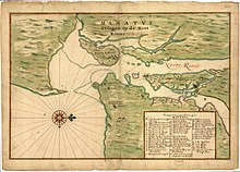
In 1634 one of the first "bouweries", or homesteads, in the colony of New Netherland was built at Communipaw on the west bank of the North River as part of Pavonia, a patroonship of Amsterdam businessman Michael Pauw.[2][4] Bout was the second of three superintendents for the patroonship. The spit of land on which the house was built (near contemporary Liberty State Park in Jersey City) was called Jan de Lacher's Hoeck.[5] or Jan the Laugher's Point, apparently in reference to his boisterous character. It was at Bout's homestead that the Tappan and Wecquaesgeek had taken refuge, and was where they were attacked[6][7] in 1643 in the incident known as the Pavonia Massacre which led to Kieft's War.[4]
Bout was member of the Council of Eight Men,[8] a citizens advisory board for the Commonality of New Amsterdam that was instrumental in the removal of William Kieft as the Director of New Netherland, the Twelve Men and the Nine Men.[2] He accompanied Adriaen van der Donck to the Netherlands to present grievances to the States-General of the Netherlands about mismanagement by the Dutch West India Company.[9] This led to the granting of a municipal charter for New Amsterdam. When given its municipal charter in 1653[10] City Council] the Commonality of New Amsterdam included the isle of Manhattan, Staaten Eylandt, Pavonia and the Lange Eylandt towns.[11] Bout was later a signatory for the 1658 treaty-deed purchasing the lands of lower Bergen Hill that would become Hudson County.
Bout later moved to Brooklyn, where he had acquired land patents including the area around the Gowanus Canal[12] As noted in The Iconography of Manhattan Island's Key to the Castello Plan, Bout owned property on Manhattan Island, specifically Block H, No. 1 and Block D, No. 21.[13]
See also
| New Netherland series |
|---|
| Exploration |
| Fortifications: |
| Settlements: |
| The Patroon System |
|
| People of New Netherland |
| Flushing Remonstrance |
 |
References
- ^ Margery Freas, Daughters of Jan Evertse Bout, RootsWeb, 1999
- ^ a b c Winfield, Charles Hardenburg (25 June 2017). "History of the county of Hudson, New Jersey, from its earliest settlement to the present time. By Charles H. Winfield". Retrieved 25 June 2017.
- ^ "Earliest known Manhattan map made in 1639" (PDF). The New York Times. March 25, 1917. Retrieved 2012-12-26.
- ^ a b "Jan Evertszen Bout". www.greenapple.com. Archived from the original on 4 September 2017. Retrieved 25 June 2017.
- ^ "Communipaw". www.njcu.edu. Archived from the original on 4 June 2016. Retrieved 25 June 2017.
- ^ Vanvugt, Ewald. "David Pietersz De Vries (1593-1655)". www.antenna.nl. Retrieved 25 June 2017.
- ^ "Columbia University Libraries: Remonstrance of New Netherland and the occurrences there". www.columbia.edu. Retrieved 25 June 2017.
- ^ Jacobs, Jaap (2005). New Netherland: A Dutch Colony In Seventeenth-Century America. ISBN 90-04-12906-5.
...replaced by Jan Evertz Bout....
- ^ Shorto, Russell (2004). The Island at the Center of the World: The Epic Story of Dutch Manhattan and the Forgotten Colony that Shaped America. Random House. ISBN 1-4000-7867-9.
- ^ "New York City Council - History of the City Council". Archived from the original on 2012-06-20. Retrieved 2013-01-01.
- ^ :Map of Long Island Townshtip
- ^ Stiles, Henry R., History of the City of Brooklyn: Including the old town and village of Brooklyn, the town of Bushwick, and the village and city of Williamsburgh". Brooklyn, N.Y.: Pub. by subscription, 1867-1870. July 5, 2005
- ^ Stokes, I. N. Phelps (1915–1928), The Iconography of Manhattan Island 1498-1909 (Key to the Castello Plan) (PDF), vol. 2, Robert H. Dodd
