Shin-maruko Station
TY10 MG10 Shin-maruko Station 新丸子駅 | ||||||||||||||||
|---|---|---|---|---|---|---|---|---|---|---|---|---|---|---|---|---|
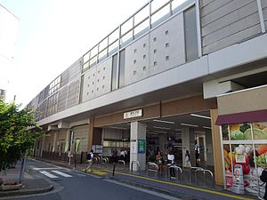
 Shin-maruko Station, west exit | ||||||||||||||||
| General information | ||||||||||||||||
| Location | 766 Shinmaruko-cho, Nakahara Ward, Kawasaki City Kanagawa Prefecture 211-0005 Japan | |||||||||||||||
| Coordinates | 35°34′50″N 139°39′43″E / 35.580621°N 139.661918°E | |||||||||||||||
| Operated by | ||||||||||||||||
| Line(s) |
| |||||||||||||||
| Distance | 10.3 km (6.4 mi) from Shibuya | |||||||||||||||
| Platforms | 2 island platforms | |||||||||||||||
| Tracks | 4 | |||||||||||||||
| Connections | ||||||||||||||||
| Construction | ||||||||||||||||
| Structure type | Elevated | |||||||||||||||
| Other information | ||||||||||||||||
| Station code | TY10, MG10 | |||||||||||||||
| Website | Official website | |||||||||||||||
| History | ||||||||||||||||
| Opened | 14 February 1926 | |||||||||||||||
| Passengers | ||||||||||||||||
| FY2019 | 27,539 | |||||||||||||||
| Services | ||||||||||||||||
| ||||||||||||||||
| ||||||||||||||||

Shin-maruko Station (新丸子駅, Shin-maruko-eki) is a junction passenger railway station located in Nakahara Ward, Kawasaki, Kanagawa Prefecture, Japan and operated by the private railway company Tokyu Corporation.
Lines
Shin-maruko Station is served by the Tōkyū Tōyoko Line and is 10.3 kilometers (6.4 mi) from the starting point of the line at Shibuya. It is also served by the Tōkyū Meguro Line and is 8.6 kilometers (5.3 mi) from the terminus of that line at Meguro Station.
Station layout
The station consists of two island platforms serving four tracks with an elevated station building.
Platforms
| 1 | TY Tokyu Toyoko Line |
|
| 2 | MG Tokyu Meguro Line |
|
| 3 | MG Tokyu Meguro Line | for Ōokayama and Meguro N Namboku Line for Akabane-iwabuchi SR Saitama Rapid Railway Line for Urawa-misono I Mita Line for Nishi-takashimadaira |
| 4 | TY Tokyu Toyoko Line | for Jiyūgaoka, Naka-Meguro, and Shibuya F Fukutoshin Line for Shinjuku-sanchome, Ikebukuro, Kotake-mukaihara, and Wakoshi TJ Tōbu Tōjō Line for Shinrinkōen |
History
Shin-maruko Station opened as one of the original Tōyoko Line stations on February 14, 1926.
Passenger statistics
In fiscal 2019, the station was used by an average of 27,539 passengers daily.[1]
The daily average passenger figures for previous years are as shown below.
| Fiscal year | Tōyoko Line | Meguro Line | |
|---|---|---|---|
| 2005 | 20,750 | 4,671 | [2] |
| 2010 | 19,785 | 5,738 | [3] |
| 2015 | 20,131 | 6,171 | [4] |
Surrounding area
- Sumiyoshi Shrine
- Kanto Workers' Health and Safety Hospital
- Tokyu Corporation Former Sumiyoshi Depot
- Tokyu Driving School / Train Driver Training Center
- Kanagawa Prefectural Sumiyoshi High School
- Hosei University Second Junior and Senior High School
See also
References
- ^ "2020年度乗降人員" (in Japanese). Japan: Tokyu Corporation. 2020. Retrieved 11 August 2020.
- ^ 神奈川県県勢要覧(平成18年度) [Kanagawa Prefecture official statistics (fiscal 2005)] (PDF) (in Japanese). Japan: Kanagawa Metropolitan Government. Retrieved 26 March 2021.
- ^ 神奈川県県勢要覧(平成23年度) [Kanagawa Prefecture official statistics (fiscal 2010)] (PDF) (in Japanese). Japan: Kanagawa Prefecture. Retrieved 26 March 2021.
- ^ 神奈川県県勢要覧(平成28年度 [Kanagawa Prefecture official statistics (fiscal 2010)] (PDF) (in Japanese). Japan: Kanagawa Prefecture. Retrieved 26 March 2021.
External links
![]() Media related to Shin-maruko Station at Wikimedia Commons
Media related to Shin-maruko Station at Wikimedia Commons
- Official website (in Japanese)


