Dăeni
Appearance
Dăeni | |
|---|---|
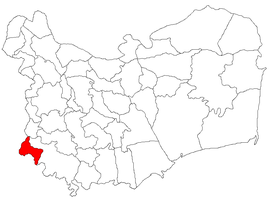
 Location in Tulcea County | |
| Coordinates: 44°50′N 28°07′E / 44.833°N 28.117°E | |
| Country | Romania |
| County | Tulcea |
| Government | |
| • Mayor (2020–2024) | Marian Gherghișan[1] (PNL) |
Area | 42.00 km2 (16.22 sq mi) |
| Elevation | 24 m (79 ft) |
| Population (2021-12-01)[2] | 1,772 |
| • Density | 42/km2 (110/sq mi) |
| Time zone | EET/EEST (UTC+2/+3) |
| Postal code | 827065 |
| Area code | +40 x40 |
| Vehicle reg. | TL |
| Website | www |
Dăeni is a commune in Tulcea County, Northern Dobruja, Romania. It is composed of a single village, Dăeni.
The commune is located in the southwestern corner of the county, on the border with the Brăila and Constanța counties, 76 km (47 mi) from the county seat, Tulcea. It lies on the right bank of the Măcin Branch of the Danube.
The Salcia hamlet lies right across the Danube, on the Great Brăila Island. During the 1950s and 1960s, the Romanian Communist regime operated here the Salcia penal colony (part of the Brăila Pond labor camps).[3]
References
[edit]- ^ "Results of the 2020 local elections". Central Electoral Bureau. Retrieved 14 June 2021.
- ^ "Populaţia rezidentă după grupa de vârstă, pe județe și municipii, orașe, comune, la 1 decembrie 2021" (XLS). National Institute of Statistics.
- ^ Oprea, Marius (September 12, 2022). ""Blocul cadrelor" de la Salcia – singurul vestigiu al lagărelor din România. Restul au fost distruse de "blocul cadrelor" incă vii din Securitate". MediaFax (in Romanian). Retrieved December 6, 2023.


