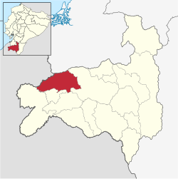
Puyango Canton
Appearance
This article has multiple issues. Please help improve it or discuss these issues on the talk page. (Learn how and when to remove these messages)
|
Puyango | |
|---|---|
 Location of Loja Province in Ecuador. | |
 Puyango Canton in Loja Province | |
| Coordinates: 3°52′12″S 80°5′24″W / 3.87000°S 80.09000°W | |
| Country | Ecuador |
| Province | Loja |
| Area | |
• Total | 637.3 km2 (246.1 sq mi) |
| Population (2022 census)[1] | |
• Total | 16,257 |
| • Density | 26/km2 (66/sq mi) |
Puyango is a canton of the Province of Loja, Ecuador. It is located in the west of the province, and borders the cantons of Paltas, Celica, Pindal, and Zapotillo.
References
[edit]- ^ Citypopulation.de Population and area of Puyango Canton
Sources
[edit]- World-Gazetteer.com
