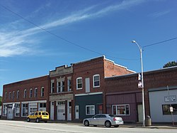
Ijem Avenue Commercial Historic District
Ijem Avenue Commercial Historic District | |
 | |
| Location | Ijem Ave. between Railroad St. and Main St., Nichols, Iowa |
|---|---|
| Coordinates | 41°28′52″N 91°18′30″W / 41.48111°N 91.30833°W |
| Architectural style | Italianate Neolassical Commercial |
| NRHP reference No. | 100005566[1] |
| Added to NRHP | September 18, 2020 |
The Ijem Avenue Commercial Historic District is a historic district in Nichols, Iowa. It was listed on the National Register of Historic Places in 2020.[1] It is composed of 12 one and two-story commercial buildings that date from the late nineteenth to the mid-twentieth century.[2] It also includes one modern infill building. Nichols is a small town in western Muscatine County and was an important railroad shipping point and market town from about 1885 to about 1920. It was located along the Burlington, Cedar Rapids and Northern Railway, which came to town in 1871, and the Muscatine and Western Railroad, which arrived two years later. The two railroads intersected on the west side of the central business district, and both were incorporated into the Chicago, Rock Island and Pacific Railroad in the 1880s. The brick commercial buildings in the historic district were built during this period of time. They are attached one and two-story brick structures. The oldest buildings reflect the Italianate style with their arched windows, while the later buildings reflect the Neolassical and Commercial styles.[2]
After the demise of the railroads in Nichols, the downtown area continued its farm-service function by focusing on highway traffic. Ijem Avenue was paved and widened in 1960 when it became part of Iowa Highway 22.
References
[edit]- ^ a b "National Register of Historic Places Program: Weekly List". National Park Service. September 25, 2020. Retrieved October 5, 2020.
- ^ a b Zachary Smith (May 4, 2018). "Nichols district needs money to get on Historic Preservation list". Muscatine Journal. Muscatine, Iowa. Retrieved October 5, 2020.
- Italianate architecture in Iowa
- Neoclassical architecture in Iowa
- Chicago school architecture in Iowa
- Commercial buildings on the National Register of Historic Places in Iowa
- National Register of Historic Places in Muscatine County, Iowa
- Historic districts on the National Register of Historic Places in Iowa
- Historic districts in Muscatine County, Iowa
- Southeast Iowa Registered Historic Place stubs


