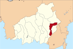
South Barito Regency
South Barito Regency
Kabupaten Barito Selatan | |
|---|---|
 Location within Central Kalimantan | |
Location in Kalimantan and Indonesia | |
| Coordinates: 1°52′00″S 114°44′00″E / 1.8667°S 114.7333°E | |
| Country | Indonesia |
| Region | Kalimantan |
| Province | Central Kalimantan |
| Capital | Buntok |
| Government | |
| • Regent | Eddy Raya Samsuri |
| • Vice Regent | Satya Titiek Atyani Djoedir |
| Area | |
| • Total | 3,410 sq mi (8,830 km2) |
| Population (2014) | |
| • Total | 132,913 |
| • Density | 39/sq mi (15/km2) |
| Time zone | UTC+7 (IWST) |
| Area code | (+62) 525 |
| Website | baritoselatankab |
South Barito Regency (Indonesian: Kabupaten Barito Selatan) is one of the thirteen regencies which divide the island of Kalimantan, Central Kalimantan Province, Indonesia. Buntok is the capital of South Barito Regency. The population of South Barito Regency was 124,128 at the 2010 Census,[1] but the latest official estimate (as at January 2014) is 132,913.
Administrative Districts
South Barito Regency consists of six districts (kecamatan), tabulated below with their populations at the 2010 Census:[2]
| District | Population 2010 Census |
|---|---|
| Jenamas | 9,071 |
| Dusun Hilir (Lower Dusun) |
15,617 |
| Karau Kuala | 15,375 |
| Dusun Selatan (South Dusun) |
49,748 |
| Dusun Utara (North Dusun) |
16,318 |
| Gunung Bintang Awai | 17,999 |
Demographics
Religion as of the Indonesia 2010 census:[3]
- Muslim 70.2%
- Protestant 18.8%
- Roman Catholic 6.8%
- Buddhist 0.1%
- Hindu 0.0%
- Confucian 0.0%
- Other 3.9%
- Not stated or not asked 0.2%


