Lypova Dolyna Raion
Appearance
Lypovodolynskyi Raion
Липоводолинський район | |
|---|---|
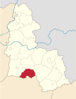
 Raion location in Sumy Oblast | |
| Coordinates: 50°35′33.1974″N 33°54′20.8368″E / 50.592554833°N 33.905788000°E | |
| Country | |
| Oblast | Sumy Oblast |
| Admin. center | Lypova Dolyna |
| Area | |
| • Total | 900 km2 (300 sq mi) |
| Population (2013) | |
| • Total | 18,825 |
| • Density | 21/km2 (54/sq mi) |
| Time zone | UTC+2 (EET) |
| • Summer (DST) | UTC+3 (EEST) |
| Website | http://ldol.sm.gov.ua/ |
Lypova Dolyna Raion (Ukrainian: Липоводолинський район) is a raion in Sumy Oblast in Central Ukraine. The administrative center of the raion is the urban-type settlement of Lypova Dolyna. Population: 18,825 (2015 est.)[1]
References
- ^ "Чисельність наявного населення України (Actual population of Ukraine)" (PDF) (in Ukrainian). State Statistics Service of Ukraine. Retrieved 1 July 2016.


