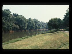
Burning Springs Complex
Appearance
Burning Springs Complex | |
 | |
| Location | Along the N bank of the Kanawha River from the confluence of Burning Springs Run, Burning Springs, West Virginia |
|---|---|
| Coordinates | 38°59′16″N 81°19′10″W / 38.98778°N 81.31944°W |
| Area | 20 acres (8.1 ha) |
| Built | 1859 |
| Architect | Rathbone Bros.; Et al. |
| NRHP reference No. | 71000884 [1] |
| Added to NRHP | May 6, 1971 |
Burning Springs Complex, also known as the Rathbone and Karns Wells, is a national historic district located at Burning Springs, Wirt County, West Virginia. It encompasses one contributing building and three contributing sites. It was historically viewed as the world's second great oil field, after the Drake Well in Pennsylvania. However, more recent scholarship including the PBS documentary Burning Springs shows it predates the Drake Well by a number of years. During the American Civil War, it was destroyed by General William E. Jones on May 9, 1863.[2]
It was listed on the National Register of Historic Places in 1971.[1]
References
- ^ a b "National Register Information System". National Register of Historic Places. National Park Service. March 13, 2009.
- ^ Clifford M. Lewis, S.J. (August 1970). "National Register of Historic Places Inventory Nomination Form: Burning Springs Complex" (PDF). State of West Virginia, West Virginia Division of Culture and History, Historic Preservation. Retrieved 2011-07-09.
Categories:
- Industrial buildings and structures on the National Register of Historic Places in West Virginia
- Historic districts in Wirt County, West Virginia
- Buildings and structures in Wirt County, West Virginia
- National Register of Historic Places in Wirt County, West Virginia
- American Civil War sites
- West Virginia in the American Civil War
- Oil fields of the United States
- Historic districts on the National Register of Historic Places in West Virginia
- Energy infrastructure on the National Register of Historic Places
- West Virginia Registered Historic Place stubs


