Jomda County
Jomda County
江达县 • འཇོ་མདའ་རྫོང་། | |
|---|---|
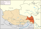
 Location of Jomda County within Tibet | |
| Coordinates: 32°43′12″N 97°57′09″E / 32.72000°N 97.95250°E | |
| Country | People's Republic of China |
| Autonomous region | Tibet |
| Prefecture-level city | Chamdo |
| Time zone | UTC+8 (China Standard) |
'Jomda County, (Tibetan: འཇོ་མདའ་རྫོང་, Wylie: jo mda' rdzong, ZYPY: Jomda Zong; simplified Chinese: 江达县; traditional Chinese: 江達縣; pinyin: Jiāngdá Xiàn) is a county of the Chamdo Prefecture in the Tibet Autonomous Region.
Towns and townships
- Jomda Town (Standard Tibetan: འཇོ་མདའ་, Chinese: 江达镇)
- Gamtog Town (སྐམ་ཐོག་, 岗托镇)
- Qongkor Township (ཆོས་འཁོར་, 邓柯乡)
- Üpäl Township (ཨུད་དཔལ་, 岩比乡)
- Kargang Township (མཁར་སྒང་, 卡贡乡)
- Sibda Township (སྲིབ་མདའ་, 生达乡)
- Nyaxi Township (ཉ་གཤིས་, 娘西乡)
- Zigar Township (རྫི་སྒར་, 字呷乡)
- Qu'nyido Township (ཆུ་གཉེས་མདོ་, 青泥洞乡)
- Woinbodoi Township (དབོན་པོ་སྟོད་, 汪布顶乡)
- Dêrdoin Township (གཏེར་སྟོན་, 德登乡)
- Tongpu Township (གདོང་ཕུ་, 同普乡)
- Bolo Township (སྤོ་, 波罗乡)
Transport
Towns and villages

