
Beiersdorf-Freudenberg
Beiersdorf-Freudenberg | |
|---|---|
Location of Beiersdorf-Freudenberg within Märkisch-Oderland district 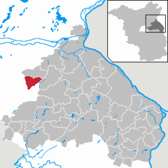 | |
 Beiersdorf-Freudenberg  Beiersdorf-Freudenberg | |
| Coordinates: 52°41′48″N 13°48′5″E / 52.69667°N 13.80139°E | |
| Country | Germany |
| State | Brandenburg |
| District | Märkisch-Oderland |
| Municipal assoc. | Falkenberg-Höhe |
| Subdivisions | 2 Ortsteile |
| Government | |
| • Mayor | Willi Huwe (Ind.) |
| Area | |
| • Total | 25.08 km2 (9.68 sq mi) |
| Elevation | 85 m (279 ft) |
| Population (2022-12-31)[1] | |
| • Total | 628 |
| • Density | 25/km2 (65/sq mi) |
| Time zone | UTC+01:00 (CET) |
| • Summer (DST) | UTC+02:00 (CEST) |
| Postal codes | 16259 |
| Dialling codes | 033451 |
| Vehicle registration | MOL |
Beiersdorf-Freudenberg is a municipality in the district Märkisch-Oderland, in Brandenburg, Germany.
Demography

|
|
Photogallery
- Beiersdorf
-
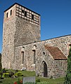 Church
 -
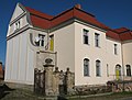 Manor
Manor -


References
- ^ "Bevölkerungsentwicklung und Bevölkerungsstandim Land Brandenburg Dezember 2022" (PDF). Amt für Statistik Berlin-Brandenburg (in German). June 2023.
- ^ Detailed data sources are to be found in the Wikimedia Commons.Population Projection Brandenburg at Wikimedia Commons
External links
![]() Media related to Beiersdorf-Freudenberg at Wikimedia Commons
Media related to Beiersdorf-Freudenberg at Wikimedia Commons
This Brandenburg location article is a stub. You can help Wikipedia by expanding it. |