Pingualuit National Park
Appearance
| Parc national des Pingualuit | |
|---|---|
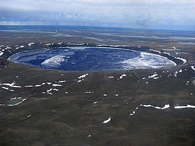
 Pingualuit Crater | |
| Location | Kativik, Quebec, Canada |
| Nearest city | Kangiqsujuaq |
| Coordinates | 61°18′00″N 73°40′00″W / 61.30000°N 73.66667°W |
| Area | 1133.90 km² |
| Established | January 1, 2004 |
| Governing body | Kativik Regional Government |
Pingualuit National Park (French: Parc national des Pingualuit) is a 1,133.90 km2 (437.80 sq mi) provincial park located in the Ungava Peninsula 100 km (62 mi) south-west of the Inuit village of Kangiqsujuaq. The park protects the Pingualuit crater, a young meteorite crater.
The park is managed by the Kativik Regional Government.
See also
External links
Wikimedia Commons has media related to Parc national des Pingualuit.
