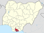
Emohua
Appearance
Emohua | |
|---|---|
| Coordinates: 4°53′0″N 6°52′0″E / 4.88333°N 6.86667°E | |
| Country | Nigeria |
| State | Rivers State |
| Date created | 1991 |
| Seat | Emohua Town |
| Government | |
| • Type | Caretaker Committee |
| • Caretaker Chairman | Sir Bright C. Ikonwa (People's Democratic Party) |
| Time zone | UTC+1 (WAT) |
Emohua is a local government area in Rivers State, Nigeria. Its headquarters are in the town of Emohua.
Emohua consists of fourteen political wards and the predominant occupation is farming.
It has an area of 831 km2 (321 sq mi) and a population of 201,901 at the 2006 census.
The postal code of the area is 511.[1]
High Chief Tom Aliezi is the Executive Chairman of Emohua Local Government Area.[2]
References
- ^ "Post Offices- with map of LGA". NIPOST. Archived from the original on 2009-10-07. Retrieved 2009-10-20.
- ^ "Emohua L.G.A Council Chairman Inaugurated The Vice Chairman And Fourteen Councillors".


