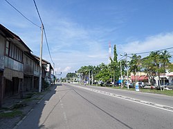
Sungai Rambai
Appearance
Sungai Rambai | |
|---|---|
 | |
 | |
| Country | Malaysia |
| State | Melaka |
| District | Jasin |
Sungai Rambai (Chinese: 双溪南眉) is a mukim in Jasin District, Melaka, Malaysia. It is situated along the federal route ![]() FT 5 to Muar. It is the last town in Malacca before crossing Kesang River into Johor.[1]
FT 5 to Muar. It is the last town in Malacca before crossing Kesang River into Johor.[1]
Tourist attractions
- Sungai Rambai Aerodrome
- Sungai Rambai Recreational Park
- Laman Deris
See also
- List of cities and towns in Malaysia by population
- Mahligai Ratu Cahaya
- Kesultanan Dompu
- Pusat Gerakan Belia (PGB)
References
- ^ "Melaka - Attraction - Jasin Attractions". www.melaka.org.my. Archived from the original on July 18, 2009. Retrieved 2009-07-30.
2°07′N 102°30′E / 2.117°N 102.500°E
