Tranqui Island
Appearance
Native name: Isla Tranqui (de Chiloe) | |
|---|---|
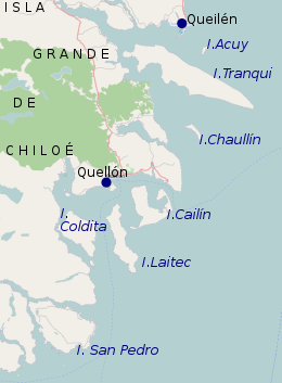
 South east of Chiloé Island: Quellón, Chaullín, Acuy, Tranqui, Coldita, Cailin, Laitec, Queilén | |
| Geography | |
| Coordinates | 42°57′40″S 73°28′06″W / 42.961073°S 73.46826°W |
| Administration | |
| Region | Los Ríos |
| Province | Chiloé Province |
| Commune | Queilén |
| Additional information | |
| NGA UFI=-903291 | |
Tranqui is an island of the Chiloé Archipelago in southern Chile. It has three sectors: San Jose, Tranqui Nepué and Sentinel, all with small populations. A significant part of its forest still has not been touched by the subsistence agriculture which forms the bulk of the province's rural economy.[1]
References
- ^ "Isla Tranqui" (in Spanish). Archived from the original on 2009-12-07.

