| Year | | |
|---|
| 1875 | 12,231 | — |
|---|
| 1890 | 11,579 | −0.36% |
|---|
| 1910 | 11,868 | +0.12% |
|---|
| 1925 | 12,341 | +0.26% |
|---|
| 1933 | 11,369 | −1.02% |
|---|
| 1939 | 11,101 | −0.40% |
|---|
| 1946 | 15,596 | +4.98% |
|---|
| 1950 | 16,702 | +1.73% |
|---|
| 1964 | 12,774 | −1.90% |
|---|
| 1971 | 12,328 | −0.51% |
|---|
| 1981 | 9,601 | −2.47% |
|---|
| 1985 | 9,127 | −1.26% |
|---|
| 1989 | 8,551 | −1.62% |
|---|
| 1990 | 8,427 | −1.45% |
|---|
| | Year | | |
|---|
| 1991 | 8,225 | −2.40% |
|---|
| 1992 | 8,050 | −2.13% |
|---|
| 1993 | 8,055 | +0.06% |
|---|
| 1994 | 8,097 | +0.52% |
|---|
| 1995 | 8,117 | +0.25% |
|---|
| 1996 | 8,122 | +0.06% |
|---|
| 1997 | 8,174 | +0.64% |
|---|
| 1998 | 8,218 | +0.54% |
|---|
| 1999 | 8,285 | +0.82% |
|---|
| 2000 | 8,211 | −0.89% |
|---|
| 2001 | 8,156 | −0.67% |
|---|
| 2002 | 8,095 | −0.75% |
|---|
| 2003 | 7,977 | −1.46% |
|---|
| 2004 | 7,935 | −0.53% |
|---|
| | Year | | |
|---|
| 2005 | 7,847 | −1.11% |
|---|
| 2006 | 7,748 | −1.26% |
|---|
| 2007 | 7,674 | −0.96% |
|---|
| 2008 | 7,604 | −0.91% |
|---|
| 2009 | 7,479 | −1.64% |
|---|
| 2010 | 7,387 | −1.23% |
|---|
| 2011 | 7,257 | −1.76% |
|---|
| 2012 | 7,178 | −1.09% |
|---|
| 2013 | 7,082 | −1.34% |
|---|
| 2014 | 7,050 | −0.45% |
|---|
| 2015 | 7,003 | −0.67% |
|---|
| 2016 | 6,934 | −0.99% |
|---|
| 2017 | 6,898 | −0.52% |
|---|
| 2018 | 6,881 | −0.25% |
|---|
|

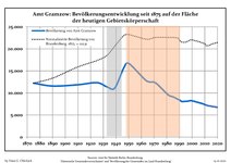 Development of population since 1875 within the current Boundaries (Blue Line: Population; Dotted Line: Comparison to Population development in Brandenburg state; Grey Background: Time of Nazi Germany; Red Background: Time of communist East Germany)
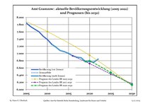 Recent Population Development and Projections (Population Development before Census 2011 (blue line); Recent Population Development according to the Census in Germany in 2011 (blue bordered line); Official projections for 2005-2030 (yellow line); for 2014-2030 (red line); for 2017-2030 (scarlet line)
