
Ben Shemen
Ben Shemen
| |
|---|---|
 | |
 Ben Shemen | |
| Coordinates: 31°57′14.4″N 34°55′29.64″E / 31.954000°N 34.9249000°E | |
| Country | Israel |
| District | Central |
| Council | Hevel Modi'in |
| Affiliation | Moshavim Movement |
| Founded | 1905 (original) 1952 (re-establishment) |
| Population (2022)[1] | 881 |

Ben Shemen (Template:Lang-he-n) is a moshav in central Israel. Located around four kilometres east of Lod, it falls under the jurisdiction of Hevel Modi'in Regional Council. In 2022 it had a population of 881.[1]
Etymology
The village's name is taken from Isaiah 5:1;
Let me sing of my well-beloved, a song of my beloved touching his vineyard. My well-beloved had a vineyard in a very fruitful hill.[2]
and also reflects the JNF's planting of olive trees in this area.[3]
History
The moshav was founded in 1905, and was one of the first villages established on Jewish National Fund land;[3] the first Jewish National Fund forest is also located in Ben Shemen.[3] According to a census conducted in 1922 by the British Mandate authorities, Ben Shemen had a population of 90 Jews.[4] Which had increased in the 1931 census to 353 residents, in 30 houses.[5] In 1923 it was split in two, with a group of trial farms eventually becoming a separate moshav, Kerem Ben Shemen.
The Ben Shemen Youth Village was established adjacent to the moshav in 1927 and is today a large agricultural boarding school.[6][3]
During World War II, Ben Shemen was the site of a British search for weapons. Similar searches were a common British response to Jewish opposition to the White Paper of 1939.[7] In 1947 Ben Shemen had a population of 75.[3] The village experienced extensive damage during the early days of the 1948 Arab–Israeli war and had to be reconstructed.[3] Immigrants from Romania joined the moshav in 1952. Some houses were built by Bezalel Academy of Art and Design founder Boris Schatz.
-
 Ben Shemen 1942 1:20,000
 -
 Ben Shemen 1945 1:250,000
 -
 Depopulated villages in the Ramle Subdistrict


-
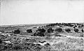
 Ben Shemen 1948. Photograph from Palmach archive
 -
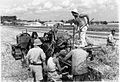
 Ben Shemen. 1948. Used as a base by the Yiftach Brigade
 -
 Ben Shemen 1948. Dining room
 -
 Ben Shemen. Harvest
 -
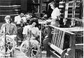 Ben Shemen. Processing wool
 -
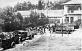 Ben Shemen being evacuated in early 1948


Notable residents
See also
References
- ^ a b "Regional Statistics". Israel Central Bureau of Statistics. Retrieved 21 March 2024.
- ^ Isaiah Chapter 5 Mechon Mamre
- ^ a b c d e f Jewish National Fund (1949). Jewish Villages in Israel. Jerusalem: Hamadpis Liphshitz Press. p. 16.
- ^ [1]
- ^ Mills, 1932, p. 19
- ^ Roth, Chaya H. (September 16, 2008). The fate of Holocaust memories: transmission and family dialogues. New York, NY: Palgrave Macmillan. p. 83.
- ^ Anita, Shapira (1992). Land and Power, The Zionist Resort to Force. Oxford: Oxford University Press. p. 288.
External links
- Ben Shemen, Cross-Israel Highway: Reproduction of an oil press Israel Antiquities Authority