Tibbetts Point Light
 Tibbetts Point Lighthouse | |
 | |
| Location | Tibbetts Point on Lake Ontario at the St Lawrence River |
|---|---|
| Coordinates | 44°6′00″N 76°22′12″W / 44.10000°N 76.37000°W |
| Tower | |
| Foundation | Natural/Emplaced |
| Construction | Brick/Stucco |
| Automated | 1981 |
| Height | 58 feet (18 m) |
| Shape | Conical frustum |
| Markings | White w/ Black Lantern |
| Heritage | National Register of Historic Places listed place |
| Light | |
| First lit | 1854 |
| Focal height | 69 feet (21 m) |
| Lens | Fourth Order Fresnel lens |
| Range | 16 nautical miles (30 km; 18 mi) |
| Characteristic | Occulting White (Oc W 10s) |
Tibbetts Point Light | |
| Location | Cape Vincent, New York |
| Area | 5 acres (2.0 ha) |
| Built | 1854 |
| MPS | U.S. Coast Guard Lighthouses and Light Stations on the Great Lakes TR |
| NRHP reference No. | 84002412[1] |
| Added to NRHP | July 19, 1984 |

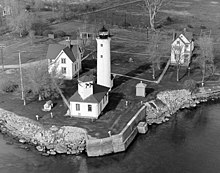
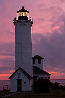
The Tibbetts Point Lighthouse is located in Cape Vincent (town), New York. The land upon which the lighthouse stands is a part of a 600-acre (240 ha) grant of land to Captain John Tibbetts of Troy, New York. The lighthouse is a circular tower that stands 69 feet (21 m) above the water
The current lighthouse was constructed in 1854.
The Tibbetts Point Lighthouse is on the Great Lakes Seaway Trail.
Its Fresnel lens is still used. Only 70 such lenses are still operational in the United States, 16 being on the Great Lakes of which two are in New York.[4]
Tibbetts Point Light is listed on the National Register of Historic Places.
Cultural
The Archives Center at the Smithsonian National Museum of American History has a collection (#1055) of souvenir postcards of lighthouses and has digitized 272 of these and made them available online. These include postcards of Tibbetts Point Light [5] with links to customized nautical charts provided by National Oceanographic and Atmospheric Administration.
Notes
- ^ "National Register Information System". National Register of Historic Places. National Park Service. November 2, 2013.
- ^ ARLHS World List of Lights
- ^ Light List, Volume VII, Great Lakes (PDF). Light List. United States Coast Guard.
- ^ United States Coast Guard, Fresnel Lenses Still in Operation. Archived 2009-03-25 at Archive-It
- ^ Smithsonian lighthouse postcards
References
DeWire, Elinor, "Tibbets Point Lighthouse." Mariners Weather Log (Fall 1991), pp. 30–31.
Further reading
- Oleszewski, Wes. Great Lakes Lighthouses, American and Canadian: A Comprehensive Directory/Guide to Great Lakes Lighthouses, (Gwinn, Michigan: Avery Color Studios, Inc., 1998) ISBN 0-932212-98-0.
- Price, Scott T. "U. S. Coast Guard Aids to Navigation: A Historical Bibliography". United States Coast Guard Historian's Office.
- U.S. Coast Guard. Historically Famous Lighthouses (Washington, D.C.: Government Printing Office, 1957).
- Wright, Larry and Wright, Patricia. Great Lakes Lighthouses Encyclopedia Hardback (Erin: Boston Mills Press, 2006) ISBN 1-55046-399-3
External links
![]() Media related to Tibbetts Point Light at Wikimedia Commons
Media related to Tibbetts Point Light at Wikimedia Commons
- Tibbetts Point information from the National Park Services Maritime Heritage Program
- Tibbetts Point information from the Lighthouse Getaway
- Lighthouses of the Great Lakes Seaway Trail
- Tibbetts Point Lighthouse
- Lighthouse Friends site
- "Historic Light Station Information and Photography: New York". United States Coast Guard Historian's Office. Archived from the original on 2017-05-01.
- National Park Service Historic Lighthouses
- USCG list of Fresnel lenses still in operation December 2008


