Jayena
Appearance
Jayena | |
|---|---|
city | |
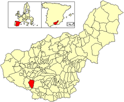
 Location of Jayena | |
| Country | Spain |
| Province | Granada |
| Municipality | Jayena |
| Area | |
| • Total | 80 km2 (30 sq mi) |
| Elevation | 912 m (2,992 ft) |
| Population (2018)[1] | |
| • Total | 1,104 |
| • Density | 14/km2 (36/sq mi) |
| Time zone | UTC+1 (CET) |
| • Summer (DST) | UTC+2 (CEST) |
Jayena is a municipality located in the province of Granada, Spain. According to the 2005 census (INE), the city has a population of 1237 inhabitants.
The village is just north of the Sierras of Tejeda, Almijara and Alhama Natural Park.
During the Andalusian earthquake of 25 December 1884 more than 58% of the houses were destroyed, and the rest were badly damaged. 10 to 11 deaths were reported, a number that later rose to 17, and 18 were seriously injured. 87 aftershocks were felt from December 25, 1884 to January 16, 1885.[2]
References
- ^ Municipal Register of Spain 2018. National Statistics Institute.
- ^ Vidal Sánchez, Francisco (2011), "Terremoto de Alhama de Granada de 1884 y su impacto", Anuari Verdaguer (in Spanish) (19): 27, retrieved 2019-08-20
36°57′N 3°49′W / 36.950°N 3.817°W


