
Bajgora
Bajgorë
Bajgora | |
|---|---|
Village | |
 | |
 Bajgorë Location in Kosovo | |
| Coordinates: 42°57′08″N 21°00′14.4″E / 42.95222°N 21.004000°E | |
| Location | |
| District | Mitrovicë |
| Municipality | Mitrovicë |
| Population (2011)[1] | |
| • Total | 1,098 |
| Time zone | UTC+1 (CET) |
| • Summer (DST) | UTC+2 (CEST) |
Bajgora (in Albanian and Serbian; Бајгора) is a village in Kosovo[a]. Located in the municipality of Kosova Mitrovica. It is located in the south of the Kopaonik range. It is just a few kilometers south from the Oshtro Koplje peak rising up to 1,789 m (5,869 ft) high. According to the 2011 census, it had 1,098 inhabitants
Bajgora was the scene of Kosovo Liberation Army activity during the Kosovo War of 1999.[2][3]
-
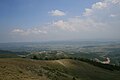 Overview
 -
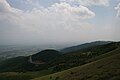 Another Overview

Notes and references
Notes:
References:
- ^ 2011 Kosovo Census results
- ^ Chris Bird (January 12, 1999). "Shooting of aide puts Kosovo on brink of war". The Guardian.
- ^ Steven Erlanger (May 11, 1999). "Crisis in the Balkans: The Serbs; Belgrade Says Pullout In Kosovo Has Begun". The New York Times.
External links
This Kosovo location article is a stub. You can help Wikipedia by expanding it. |