
Manauli Fort
| Manauli Fort (ਮਨੌਲੀ ਕਿਲਾ) | |
|---|---|
| Part of Mohali | |
| ,Mohali, Punjab, India | |
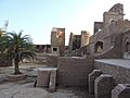
 Front view of Manauli Fort | |
 Manauli Fort (ਮਨੌਲੀ ਕਿਲਾ) | |
| Coordinates | 30°38′37″N 76°43′27″E / 30.64361°N 76.72417°E |
| Type | Fort |
| Site information | |
| Controlled by | Government of Punjab (India) |
| Open to the public | Yes |
| Condition | Not Good |
| Site history | |
| Built by | Nawab Kapur singh (owner Jat) |
Manauli Fort is located in the Manauli village of Mohali district, Punjab, India. It is 11 kilometres (7 mi) from Mohlali city and nearly 4 km away from International Chandigarh Airport Road Mohali. Manauli is a small village with a population of 3,919 and 693 households (2011 Census). As per land record area of the village is 738 hectares (1,820 acres) (s.no. 85).[1] The fort is 6.1 metres (20 ft) above the village habitation level.
Gallery
-
 Manauli Fort, district SAS Nagar Mohali, Punjab
 -
 Inner view of Manauli Fort,
 -
 Complete view of Manauli Fort complex,
 -
 Growth of Palm trees in Manauli Fort,


References
- ^ "Archived copy". Archived from the original on 4 March 2016. Retrieved 31 October 2016.
{{cite web}}: CS1 maint: archived copy as title (link)
External links
Wikimedia Commons has media related to Manauli Fort.
This article on military history is a stub. You can help Wikipedia by expanding it. |
This article about an Indian building or structure is a stub. You can help Wikipedia by expanding it. |