Piru, Indonesia
Appearance
Piru | |
|---|---|
Town | |
| Coordinates: 3°4′52″S 128°8′28″E / 3.08111°S 128.14111°E | |
| Country | Indonesia |
| Province | Maluku |
| Regency | West Seram |
| Time zone | UTC+9 (WITA) |
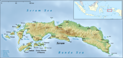
Piru is a small town and capital of the West Seram Regency on the southwestern coast of the Indonesian island of Seram.[1] On 21–22 August 1999 there was violent conflict in the area and other settlements such as Ariate, Loki, Laala and Wailissa, which resulted in 12 deaths in total on the island.[2]
References
- ^ "Seram Island (map)". Indonesiatravelingguide.com. Retrieved 8 June 2015.
- ^ Summary of World Broadcasts: Asia, Pacific. BBC Monitoring. 1999.

