Bantè
Appearance
Bantè | |
|---|---|
Commune | |
 | |
| Coordinates: 8°25′N 1°53′E / 8.417°N 1.883°E | |
| Country | Benin |
| Department | Collines Department |
| Commune | Bantè |
| Area | |
| • Total | 2,695 km2 (1,041 sq mi) |
| Population (2013) | |
| • Total | 106,945 |
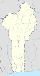
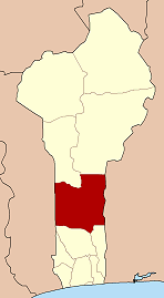
Bantè is a town, arrondissement, and commune in western Benin. It is located in the former Zou Province of which since 1999 is part of the Collines Department. The commune covers an area of 2695 square kilometres and as of 2013 had a population of 106,945 people.[1] The majority of the population is ethnically Nago specifically of the Isha subgroup, who themselves are a subgroup of the Yoruba. It is famous for the art exhibition Nago Hunters of the Bante Kingdom by Jean-Dominique Burton.
Towns and villages
Settlements in the commune of Bantè include:
Arrondissements
The nine Arrondissements in the commune of Bantè are:
References
- ^ "www.geohive.com geregistreerd via Argeweb | webhosting en domeinregistratie". www.geohive.com. Retrieved 2018-10-23.


