Dapoli
This article needs additional citations for verification. (September 2015) |
Dapoli | |
|---|---|
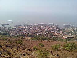
 View of pajpandhari,Dapoli from adjacent hill | |
Location in Maharashtra, India | |
| Coordinates: 17°45′32″N 73°11′8″E / 17.75889°N 73.18556°E | |
| Country | |
| State | Maharashtra |
| District | Ratnagiri |
| Elevation | 243.84 m (800.00 ft) |
| Population (2011)[1] | |
| • Total | 15,717 |
| Language | |
| • Official | Marathi |
| Time zone | UTC+5:30 (IST) |
| PIN | 415712 |
| Telephone code | 02358 |
| Vehicle registration | MH-08 |
| Nearest town | Khed |
Dapoli is a small city(Town) in Ratnagiri district, Maharashtra. It is 215 km (134 mi) from the state capital of Mumbai. Dapoli is also known as Camp Dapoli [2] as British set their camps in Dapoli. Many high-ranking British officers' graves are found in this town. The city also has an abandoned church from the time of the British Raj. Dapoli is home to one of the biggest Agricultural Universities in India, Dr. Balasaheb Sawant Konkan Krishi Vidyapeet. Dapoli is administered by the Dapoli Municipal Council.[3]
Geography
Dapoli is separated from the Sahyadri range by the Khed taluka. Dapoli has a seaboard of 50 km (31 mi) which stretches from Burondi, Kelashi to Dabhol. The coastline differs little in its general characteristics from that of other parts of Konkan. It is densely covered by coconut farms. The principal rivers are Bharja in the north and Vashishthi in the south. A small river called Jog flows through Bandhativare, Sarang and Tadil into the Arabian Sea.
The town is located at an altitude of 800 ft (240 m). It is also called "Mini Mahabaleshwar" because of its year-round cool weather. It is 8 km (5.0 mi) from the Arabian Sea and acts as the main town (Taluka headquarters) for several small surrounding villages such as Agarvayangani, kelashi, Anjarle,[4] Mandivali, Sarang, Bandhativare, Pangari, Dabhil, Sakhaloli, Bhopan, Harnai,[5] Dabhol, Onanavse, Unhavare, Jalgaon, Devke, Gavhe, [NIGADE ]Gimhavane, Asud, Vanand, Kherdi, Karde (beach), Phansu, Pichdoli, Visapur, [[Murud, Chandranagar, Ratnagiri|Murud]] and Umberghar.
Education
The town has a very old school, A. G. High School, named after the British Alfred Gadney.[6] During the time of the Raj, Dapoli was a military camp for British soldiers. Dapoli is also the home of agricultural university Dr. Balasaheb Sawant Konkan Krishi Vidyapeeth.
National High School is also an Old School from British Time.
Dapoli has a centre for Krishna Consciousness movement, youth programs for agriculture, and an undergraduate homeopathic college (Dapoli Homeopathic Medical College).
Notable residents
Dapoli is considered the birthplace of Dhondo Keshav Karve,[7] whose native village of Murud is located 9 kilometres (5.6 mi) from Dapoli.
References
- ^ "District Census Handbook" (PDF). Census of India. p. 44. Archived (PDF) from the original on 4 June 2016. Retrieved 16 April 2016.
- ^ Taluka Dapoli, Camp Dapoli History - कॅम्प दापोलीची गोष्ट, retrieved 13 January 2019
- ^ Dapoli sets example by shunning plastic - The Times of India on Mobile http://timesofindia.com/city/pune/Dapoli-sets-example-by-shunning-plastic/articleshow/14221597.cms
- ^ "Kadyvarcha Ganpati Anjarle".
- ^ "Places To Visit in Harnai | www.talukadapoli.com".
- ^ "Church in Alfred Gadney school".
- ^ "About Maharshi Karve".
External links
 Dapoli travel guide from Wikivoyage
- Taluka Dapoli - Taluka Dapoli is a collaborative project to collect documents of historical, social and cultural deposits in digital formats


