Irabu Island
Appearance
Native name: Irabu-jima (伊良部島) | |
|---|---|
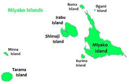
 Irabu Island is to the west of Miyako Island | |
 | |
| Geography | |
| Location | Okinawa Prefecture |
| Coordinates | 24°50′20″N 125°9′56″E / 24.83889°N 125.16556°E |
| Archipelago | Miyako Islands |
| Adjacent to | East China Sea |
| Area | 29.06 km2 (11.22 sq mi)[1] |
| Highest elevation | 89.0 m (292 ft) |
| Administration | |
| Prefecture | Okinawa Prefecture |
| Demographics | |
| Population | 4,693 (2015 national census)[1] |

Irabu Island (伊良部島, Irabu-jima) (Miyako: Irav), is an island in Miyakojima, Okinawa Prefecture, Japan. The island is connected to Miyako Island by a 3,540-metre-long (11,610 ft) bridge Irabu Ohashi (伊良部大橋),[1] which was completed in January 2015.[2] Irabu Island is also connected via six bridges to Shimoji-shima.[1] There are multiple language variants spoken on the island: Nakachi-Irabu, Kuninaka, Sawada-Nakahama, and Sarahama (which is a variant of Ikema language spoken by descendants of emigrants from Ikema Island).[3]
See also
References
- ^ a b c d "Remote island related materials (離 島 関 係 資 料)" (PDF). Archived (PDF) from the original on 15 February 2020. Retrieved 15 February 2020.
- ^ "伊良部島", Retrieved on 13 January 2018.
- ^ Heinrich, Patrick; Miyara, Shinsho; Shimoji, Michinori (17 February 2015). Handbook of the Ryukyuan Languages: History, Structure, and Use. Walter de Gruyter. pp. 405–406.
