
Torreano
Torreano | |
|---|---|
| Comune di Torreano | |
Location of Torreano  | |
 Torreano Location of Torreano in Italy  Torreano Torreano (Friuli-Venezia Giulia) | |
| Coordinates: 46°8′N 13°26′E / 46.133°N 13.433°E | |
| Country | Italy |
| Region | Friuli-Venezia Giulia |
| Province | Province of Udine (UD) |
| Area | |
| • Total | 34.9 km2 (13.5 sq mi) |
| Elevation | 189 m (620 ft) |
| Population (Dec. 2004)[2] | |
| • Total | 2,301 |
| • Density | 66/km2 (170/sq mi) |
| Time zone | UTC+1 (CET) |
| • Summer (DST) | UTC+2 (CEST) |
| Postal code | 33040 |
| Dialing code | 0432 |
| Website | Official website |
Torreano (Slovene: Tavorjana; Friulian: Torean) is a comune (municipality) in the Province of Udine in the Italian region Friuli-Venezia Giulia, located about 60 kilometres (37 mi) northwest of Trieste and about 15 kilometres (9 mi) northeast of Udine, on the border with Slovenia. As of 31 December 2004, it had a population of 2,301 and an area of 34.9 square kilometres (13.5 sq mi).[3] According to the census 1971 24,5% of the population are Slovenes.
Torreano borders the following municipalities: Kobarid (Slovenia), Cividale del Friuli, Faedis, Moimacco, Pulfero, San Pietro al Natisone.
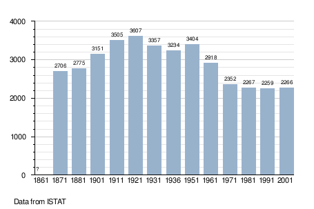
Demographic evolution
See also
References
- ^ "Superficie di Comuni Province e Regioni italiane al 9 ottobre 2011". Italian National Institute of Statistics. Retrieved 16 March 2019.
- ^ "Popolazione Residente al 1° Gennaio 2018". Italian National Institute of Statistics. Retrieved 16 March 2019.
- ^ All demographics and other statistics: Italian statistical institute Istat.
External links

| International | |
|---|---|
| Geographic | |
This article on a location in Friuli-Venezia Giulia is a stub. You can help Wikipedia by expanding it. |