Gebar Island
Appearance
This article needs additional citations for verification. (November 2013) |
Native name: Gerbar | |
|---|---|
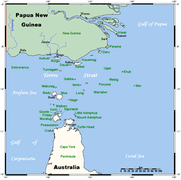
 A map of the Torres Strait Islands showing Gabba Island in the northern central waters of Torres Strait | |
| Geography | |
| Location | Northern Australia |
| Coordinates | 9°45′54″S 142°37′39″E / 9.76500°S 142.62750°E |
| Archipelago | Torres Strait Islands |
| Adjacent to | Torres Strait |
| Administration | |
| State | Queensland |
| Demographics | |
| Population | Uninhabited |
Gabba Island, or Gerbar in the native language, is an Australian island situated in the Torres Strait, and north-west of Yam Island. It is part of the Torres Strait Islands, and is uninhabited except for wild pigs.
The first recorded sighting by Europeans was by the Spanish expedition of Luís Vaez de Torres on 10 September 1606.[1]
The Newton, a 15-long-ton (15 t) ketch, was foundered and shipwrecked off Gabba Island in December 1913.
References
- ^ Hilder, Brett The voyage of Torres, Brisbane, 1980, pp.78,80
