Bridgefoot
| Bridgefoot | |
|---|---|
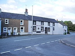
 The Dukes Head public house, Bridgefoot, now known as the Duke of Cumberland | |
Location within Cumbria | |
| Population | <500 |
| OS grid reference | NY0529 |
| Civil parish |
|
| District | |
| Shire county | |
| Region | |
| Country | England |
| Sovereign state | United Kingdom |
| Post town | Workington |
| Postcode district | CA14 |
| Dialling code | 01900 |
| Police | Cumbria |
| Fire | Cumbria |
| Ambulance | North West |
| UK Parliament | |
Bridgefoot is a village in Cumbria, historically part of Cumberland, near the Lake District National Park in England.[1][2] It is situated at the confluence of the River Marron and Lostrigg Beck, approximately 1 mile south of the River Derwent. To the south it is seamlessly joined with the village of Little Clifton.
Governance
Bridgefoot, is part of the Workington constituency of the UK parliament. The current Member of Parliament is Sue Hayman, a member of the Labour Party.[3] The Labour Party has won the seat in every general election since 1979; the Conservative Party has only been elected once in Workington since the Second World War: in the 1976 Workington by-election.[4]
For the European Parliament residents in Bridgefoot vote to elect MEP's for the North West England constituency.
For Local Government purposes it is in the Dalton Ward of Allerdale Borough Council and the Cockermouth South Division of Cumbria County Council.
Bridgefoot has its own Parish Council; Greysouthen Parish Council.[5]
References
- ^ Ordnance Survey: Landranger map sheet 89 West Cumbria (Cockermouth & Wast Water) (Map). Ordnance Survey. 2011. ISBN 9780319232057.
- ^ "Ordnance Survey: 1:50,000 Scale Gazetteer" (csv (download)). www.ordnancesurvey.co.uk. Ordnance Survey. 1 January 2016. Retrieved 30 January 2016.
- ^ "Allerdale Borough Council website". Archived from the original on 7 April 2012. Retrieved 4 April 2012.
- ^ "A vision of Britain website – general elections section". Retrieved 27 April 2012.
- ^ "Greysouthen Parish Council".

