Maracanaú
Maracanaú | |
|---|---|
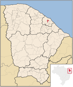
 Location in Ceará state | |
| Coordinates: 3°52′S 38°38′W / 3.867°S 38.633°W | |
| Country | Brazil |
| Region | Northeast |
| State | Ceará |
| Area | |
| • Total | 106.648 km2 (41.177 sq mi) |
| Population (2018 est.[2]) | |
| • Total | 226,128 |
| • Density | 2,100/km2 (5,500/sq mi) |
| Time zone | UTC-03:00 (BRT) |
Maracanaú is a municipality in the state of Ceará, Brazil. Its name comes from Tupi language and means "lagoon where maracanãs (red-shouldered macaws) drink", because of the presence of these birds flying over the lagoons in the city's area. Its area is 106.648 km2 (41.177 sq mi), and its population is 226,128 inhabitants (2018 estimate).[3]
Etymology
The toponym "Maracanaú" comes from the Tupi language, meaning "rio of maracanãs", through the junction of the terms marakanã (Maracanã) and 'y (Rive). His name was original town of Santo Antônio do Pitaguary. From 1890, adopted its current name.
History
The current territory of the municipality, at the time of the arrival of the first Europeans, was inhabited by Indians pitaguaris,[8] Jaçanaú, Mucunã and turtles. The holiday these ethnic groups, arose the peopling of the Lagoon of Maracanaú and, later, of the lagoons of Jaçanaú and pajuçara. In the year 1649, these Indians have received the visit of the Dutch, who cartografaram the farms of manioc and corn, as well as the ways indigenous people, during the expedition in search of the silver mines in the Sierra de Sao Tome and Principe. These plots of cassava and maize were expanded during the time in which Mathias Beck administered the islands from its military base and administrative: the Fort Schoonenborch. Maracanaú figured as part of Maranguape until, in 1875, he was faced with a major transformation, with the inauguration of the railway from Port Alberni and the train station. In the 20th century, grew the settlement around four institutions: the metropolitan train - Extension Maranguape/Fortaleza, the Sanatorium of Azusa (today Municipal Hospital), the Colony Antônio justo Fair and the Instituto Carneiro de Mendonça - Rehabilitation Center for Minors. In the years 1970, hindmarsh suffered major transformation when he was chosen to host the Industrial District of Fortaleza. In 1983, Maracanaú emancipated permanently of Maranguape, via the political action of the Movement for the Emancipation of Maracanaú, a producer of politicians with interests directly linked to Azusa. The Councilors of the Mayor of Sao gave strong support to the struggle for the emancipation of the municipality. The Councilors of the Mayor of Sao gave strong support to the struggle for the emancipation of the municipality. After the conquest of the condition of municipality, the first elected mayor was Almir Dutra. He, however, came to be murdered on 27 February 1987. The city council has passed, then, to be administered by the vice mayor José Raimundo. The city today the honors, putting his name in buildings such as the stadium under construction in the city.
Sports
The professional football team of the city is the Maracanã Esporte Clube. The team was champion of the second division of the Championship Ceará and in 2013 competed in the series A of the championship, but was demoted. He was also runner-up in the second division of the Ceará Championship in 2007.
The city also has a professional Futsal team, also called Maracanã Esporte Clube, which was champion of the Ceará Futsal Championship in 2012.
The Almir Dutra Municipal Stadium, located in the center of the city, is being built in the city and will have capacity for 18,000 people and more than 600 parking spaces for vehicles.
Subdivision
The city has 3 districts: Maracanaú (main), Pajuçara and Pitaguary besides Distrito Industrial. In total, the city has 36 neighborhoods.
- Acaracuzinho
- Alto Alegre I
- Alto Alegre II
- Alto da Mangueira
- Antônio Justa
- Boa Esperança
- Boa Vista
- Cágado
- Coqueiral
- Colônia Antônio Justa
- Centro
- Cidade Nova
- Distrito Industrial I
- Furna da Onça
- Horto
- Industrial
- Jaçanaú
- Jardim Bandeirantes
- Jari
- Jenipapeiro
- Jereissati I
- Luzardo Viana
- Mucunã
- Novo Maracanaú
- Novo Oriente
- Olho D’Água
- Pajuçara
- Pajuçara Park
- Pau-Serrado
- Parque Tijuca
- Parque Santa Maria
- Piratininga
- Santo Antônio
- Santo Sátiro
- Siqueira
- Timbó
Urban Structure
This section is empty. You can help by adding to it. (June 2019) |
Health
The health indexes of the Maracanau population are better than the Brazilian average. According to data from 2007, the infant mortality rate up to one year old was 10.5 ‰, against a Brazilian average of 16.7. The city of Maracanaú has 1.9 physicians linked to SUS for each thousand inhabitants. Rate of children accompanied by the Health Agents Program (2014): From 0 to 11 months with vaccine on day: 92.34% / From 12 to 23 months with vaccine on day: 91.83%.
Education
The city has 87 municipal schools, 16 state schools and 71 private schools. According to data from the Secretariat of Basic Education, the rate of approval in Primary Education is 94.30%, above the state, and 75.70% in High School. There are few institutions of higher education in Maracanaú, such as FADESNE (private and first in the municipality), the Federal Institute of Education, Science and Technology of Ceará, which offers undergraduate and baccalaureate degrees and postgraduate studies with an academic master's degree. In Technical Education, there are the Technical School of Maracanaú (ETM), unit of SENAI National Service of Industrial Learning, SENAP, and others.
Infrastructure
The city benefits from the Ring Road of Fortaleza, which is part of the Metropolitan Arch, helping the urban mobility of those who travel to Pecém in the northwest direction, and eastward to the BR-116. Two other state highways cut the city, the CE-060 in the East Zone (Pajuçara) and the CE-065 in the West Zone (by the Fazenda Fox environmental reserve) favoring locomotion of the municipalities of Fortaleza and Maracanaú, besides those that are in the Great Fortress and interior. The City Hall has created and duplicated avenues, improved the flow of vehicles, attracting business and favoring infrastructure, with results, since Maracanaú was one of the cities that developed the most in Brazil. Condos and apartments are being designed for the city which, today, is the second most economically wealthy statewide. Maracanaú is connected to Fortaleza by the South Line of the Fortaleza Subway, passing through important districts of the municipality as: Jereissati I and II, Novo Maracanaú, Alto Alegre, Acaracuzinho and the very center of Maracanaú.
The city also has a business complex, called Business Place Maracanaú, focused mainly on business tourism and is located between the neighborhoods of Jereissati I and Industrial District. The complex has two business towers, a modern hotel with 121 apartments, the Fair Center Shopping, a Supermarket Lagoon, among other services.
References
- ^ "Brazilian Institute of Geography and Statistics" (in Portuguese). 2017. Retrieved 27 March 2019.
2018 Area Total
- ^ "Brazilian Institute of Geography and Statistics" (PDF) (in Brazilian Portuguese). 2018. Retrieved 6 March 2019.
2018 Estimates of Population
- ^ Maracanaú - Panorama, IBGE, accessed 1 May 2019


