Miyako Islands
Appearance
Native name: Miyako-rettō (宮古列島) | |
|---|---|
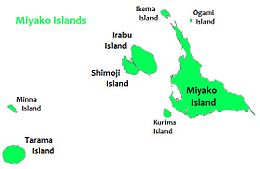
 Map of the Miyako Islands | |
 | |
| Geography | |
| Location | Pacific Ocean |
| Archipelago | Sakishima Islands |
| Adjacent to | East China Sea |
| Total islands | 12 |
| Major islands | Miyako Island, Irabu Island, Tarama Island |
| Area | 226.20 km2 (87.34 sq mi) |
| Administration | |
| Prefecture | Okinawa Prefecture |
| Demographics | |
| Population | 55,522 (January 2018) |
| Pop. density | 246.2/km2 (637.7/sq mi) |
| Ethnic groups | Miyako (Ryukyuan), Japanese |


The Miyako Islands (宮古列島, Miyako-rettō, Miyako: Myaaku, Tarama dialect: Meeku, Okinawan: Naaku) (also Miyako Sima group[1]) are a group of islands in Okinawa Prefecture, Japan, belonging to the Ryukyu Islands. They are situated between the Okinawa Island and Yaeyama Islands.
In the early 1870s, the population of the islands was estimated to number approximately 10,000.[1] Miyako island has 55,914 people, most of whom are ethnic Ryukyuans. A bridge connects Miyako Island to Ikema Island, which has 801 people. Tarama village has 1,214 people, between the two islands of Minna and Tarama.
Inhabited islands
 Miyakojima City
- Ikema Island (池間島, Ikema-jima, Miyako: Ikyaama)
- Irabu Island (伊良部島, Irabu-jima, Miyako: Irav)
- Kurima Island (来間島, Kurima-jima, Miyako: Ffyama)
- Miyako Island (宮古島, Miyako-jima, Miyako: Myaaku, Okinawan: Naaku)
- Ōgami Island (大神島, Ōgami-jima) (ja)
- Shimoji Island (下地島, Shimoji-shima, Miyako: Sïmuzï)
 Tarama Village (Miyako District)
- Minna Island (水納島, Minna-jima, Miyako: Minna)
- Tarama Island (多良間島, Tarama-jima, Miyako and Okinawan: Tarama) (ja)
See also
References
- ^ a b William Campbell (1915). "Sketches from Formosa". p. 47.
I was in some hope that, on one of our long tacks, we might have come within view of Kumi, the westernmost island of the Miyako Sima group. It lies about sixty miles east from Dome Point, and has four villages. Two or three of the islands lying further east have a much larger area than Botel Tobago, and the population of the entire group is estimated to number about ten thousand. They are said to be a poor but contented and unarmed race, in appearance similar to the Luchuans (to whom they are subject), but resembling the Japanese more in manners, customs, and language.
External links
 Miyako Islands travel guide from Wikivoyage
24°43′N 125°01′E / 24.717°N 125.017°E
