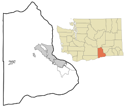
Gibbon, Washington
Appearance
Gibbon, Washington | |
|---|---|
 | |
| Coordinates: 46°14′09″N 119°39′42″W / 46.2359668°N 119.6616967°W[1] | |
| Country | United States |
| State | Washington |
| County | Benton |
| Elevation | 643 ft (196 m) |
| Time zone | UTC-8 (Pacific (PST)) |
| • Summer (DST) | UTC-7 (PDT) |
| ZIP code | 99350 |
| Area code | 509 |
| GNIS feature ID | 1511509[2] |
Gibbon is an unincorporated community in Benton County, Washington, United States, between Prosser and Benton City.
The community, primarily a railroad junction, was founded as Bender by the Northern Pacific Railway Company in 1884. In April 1896, Bender's name was changed to Gibbon in honor of U.S. Army General John Gibbon who died that same year.[4][5]
References
- ^ "Gibbon". Geographic Names Information System. United States Geological Survey, United States Department of the Interior. Retrieved 2012-10-28.
- ^ a b "US Board on Geographic Names". United States Geological Survey. 2007-10-25. Retrieved 2008-01-31.
- ^ "U.S. Census website". United States Census Bureau. Retrieved 2008-01-31.
- ^ "Station Roster Master List: Gibbon". Northern Pacific Railway Historical Association. Retrieved October 30, 2012.
- ^ "Washington Place Names database". Tacoma Public Library. Archived from the original on September 5, 2012. Retrieved October 30, 2012.


